Typhoon Rammasun
Status: Closed
Post Landfall 3 | Summary
Posting Date: July 18, 2014, 11:45:00 AM
Typhoon Rammasun Hits Hainan and Guangdong Provinces in China, Heads to Vietnam
Typhoon Rammasun made its third landfall when it hit Wenchang, on the northeastern tip of Hainan Province, China, an island province south of Hong Kong, at 6 UTC on Friday, July 18. Ten-minute maximum wind speed at landfall was 166 km/h, equivalent to a Category 3 storm on the Saffir-Simpson scale. The storm then jogged to the north, making another landfall in Zhanjiang City on the eastern coast of the Leizhou Peninsula in the southernmost part of Guangdong province in southern China.
Rammasun made landfall in China as a more intense storm than forecast, and it is one of the strongest storms to pass near Hainan Island in the observed record. Using Japan Meteorological Agency (JMA) intensity estimates for all typhoons passing within 1-degree of Hainan Island during the period 1951-2013, Rammasun is tied for the most intense storm from a minimum central pressure standpoint and tied for the second most intense from a maximum sustained wind speed perspective. Utilizing data from the Shanghai Typhoon Institute for the years 1949-2012, Rammasun is tied for the strongest storm from a wind perspective.
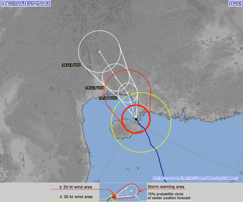
According to the JMA, as of 12 UTC July 18, Typhoon Rammasun was located at 20.3°N, 110.2°E, with minimum central pressure of 940 mb and maximum sustained winds of 166 km/h.
Meteorological Summary and Forecast
Rammasun, which weakened during its passage over the Philippines, intensified dramatically after emerging in the South China Sea, with central pressure decreasing from 970 to 940 mb, and maximum 10-minute sustained winds increasing from 130 to 166 km/h. Prior to landfall in Hainan Island, Rammasun featured a highly organized structure, typical of extremely strong typhoons. Rammasun’s intensification was due to favorable environmental conditions, including low wind shear and extremely warm sea surface temperatures, which are greater than 30°C throughout much of the South China Sea.
Precipitation so far has been observed as high as 328 mm in the last 24 hours on Hainan, and isolated, mountainous areas could get as high as 500 mm. In the next 24 hours, the Chinese Meteorological Administration is calling for 250+ mm of precipitation across northwest Hainan and the Leizhou Peninsula.
Rammasun is forecast to track to the northwest, re-emerging over the Gulf of Tonkin prior to making its final landfall just east of the China/Vietnam border at approximately 00 UTC 19 July (see JMA forecast track).

JMA forecast as of 12 UTC, July 18, 2014
Reported Impacts
Resorts, tourist attractions, tour buses, sightseeing vessels, train service on the eastern part of Hainan, and ferries to the mainland have all suspended operations at least through Saturday afternoon, after authorities issued a red typhoon alert, the highest level of warning, for the region. In advance of Rammasun, more than 40,000 people were evacuated from adjacent “county-level” cities Wenchang and Qionghai, which each comprise several towns and villages as well as farmland and urban areas. Together, these cities have a population of more than 1 million. In Hainan’s capital, Haikou, all transportation has stopped, and 13 roads have been flooded and many vehicles have been submerged. Power supplies have been cut and water supplies disrupted, with only one of three waterworks still functioning. Wind-borne debris has injured dozens. The two main airports in the province, Haikou Meilan International Airport and Sanya Phoenix International Airport, have canceled more than 250 flights, stranding more than 10,000 people. It has been reported that almost all brick-and-tile houses in Wengtian, a coastal township, have been destroyed or had their roofs ripped off and that one man was killed by wind-borne debris after his house collapsed.
In Guangdong Province, authorities had put rescue teams in place in Zhanjiang, Yangjiang, and Maoming cities, arming them with necessities. Hotels in the area of risk were evacuated, and fishing boats were called back to port. At Baoan International Airport in Shenzhen, which is close to Hong Kong, flights to and from Haikou and Sanya airports were canceled, and ferry service between Zhanjiang and Techeng Island was suspended, stranding more than 1,000 tourists on the island. Zhanjiang City, where Rammasun made its second landfall in China, is a “prefecture-level” city with nearly 7 million people comprising four urban areas, as well as townships and villages.
The northern provinces of Vietnam have begun evacuations of more than 118,000 people, with more than 1,300 in shelters already. All boats have been ordered to return to shore, and the army has been deployed to be in place for search and rescue missions. All tourist boats have been banned from Ha Long Bay. The region is also home to the country’s largest coal-mining area, Quang Ninh.
The AIR tropical cyclone team is inputting the relevant data into the AIR Typhoon Model for China to determine whether a full ALERT posting is warranted. More information will be provided next week if warranted.