Typhoon Chan-hom
Status: Closed
| Type of posting | Posting date(EST): | Summary | Downloads |
|---|---|---|---|
| Post Landfall 1 | 7/15/2015 2:00:00 PM |
|
|
| Landfall | 7/13/2015 1:00:00 PM |
|
|
| Pre-Landfall 2 | 7/10/2015 1:15:00 PM |
|
|
| Pre-Landfall 1 | 7/8/2015 2:00:00 PM |
|
Pre-Landfall 2 | Summary
Posting Date: July 10, 2015, 1:15:00 PM
Typhoon Chan-hom Tracks Toward Shanghai, China
Slowly weakening as it begins to pass over cooler ocean water off the coast of China, Typhoon Chan-hom still poses a major threat to Shanghai and other heavily populated areas nearby at it tracks toward Hangzhou Bay, with landfall expected during the day on Saturday, local time.
Meteorological Summary and Forecast
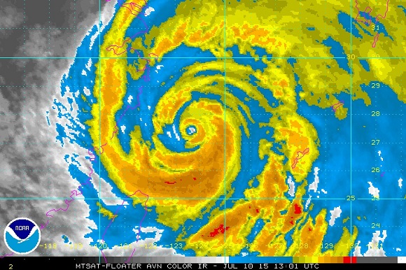
According to the Japan Meteorological Agency (JMA), Typhoon Chan-hom is located at 27.3°N, 124.0°E as of 12:00 UTC July 10, with a central pressure of 940 mb and maximum 10-minute sustained wind speeds of 85 knots (~112 mph 1-minute sustained). Over the past 24 hours, Chan-hom peaked in intensity as a Category 4 storm but is now weakening as it moves over cooler ocean water off the eastern coast of China. Nonetheless, Chan-hom has maintained a good overall structure, including a clearly defined eye and near symmetry of the cloud field, indicating that the typhoon is not experiencing much wind shear (Figure 1). Drier air is working its way toward the storm center from the north, which in combination with the cooler sea surface temperatures, should continue to weaken Chan-hom.

Figure 1. Infrared satellite image of Chan-hom at 13:01 UTC July 10, 2015. (Source: NOAA)
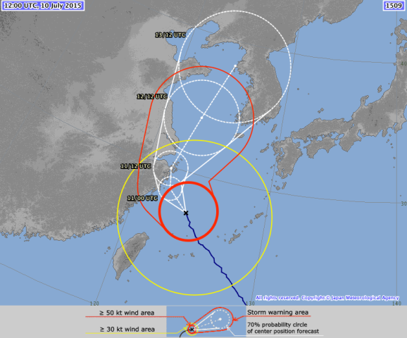
Chan-hom has generally been tracking toward the northwest around the southwestern periphery of the subtropical ridge, and this track is expected to continue for the next 12-18 hours (Figure 2). Then, in the 6-12 hours before landfall, Chan-hom is forecast to turn toward the north and then eventually the northeast around the time of landfall. The exact timing and location of the recurvature of the storm track toward the north and northeast will be critical for determining the impacts in and around Hangzhou Bay, including Shanghai, which is the third most populated metropolitan area in the world.

Figure 2. JMA track forecast for Chan-hom, as of 12:00 UTC July 10, 2015.(Source; JMA)
Possible Impacts
Areas to the right of the storm track are at greatest risk for storm surge. Even though downtown Shanghai is protected by a seawall, the integrity of that seawall could be tested if the storm does not weaken significantly before landfall and the wind direction is favorable for water to surge into Shanghai. Regardless, heavy rainfall of 1-2 feet is possible in and around Shanghai, especially if Chan-hom slows down significantly before recurving toward the northeast, which could cause major urban flooding. Strong winds could also cause some damage, but flooding appears to be the largest threat at this time.
In Taiwan the stock market, some businesses, government offices, and schools closed ahead of the storm. At least 20 people were injured and more than 30,000 lost power as Chan-hom passed Okinawa. The China Meteorological Administration (CMA) raised a red warning of typhoon Friday morning for Zhejiang and Fujian provinces and an orange warning of rainstorm for Zhejiang, Shanghai, southern Jiangsu, southeastern Anhui, northeast Fujian, and Taiwan. Flights, trains, and bus and speedboat ferry services have been canceled. Some tourist spots closed, and 60,000 people have been evacuated from coastal areas.