Typhoon Goni
Status: Closed
| Type of posting | Posting date(EST): | Summary | Downloads |
|---|---|---|---|
| Landfall | 8/25/2015 12:30:00 PM |
|
|
| Pre-Landfall 1 | 8/24/2015 2:30:00 PM |
|
Pre-Landfall 1 | Summary
Posting Date: August 24, 2015, 2:30:00 PM
Maintaining its intensity as it nears Kyushu Island, Japan, Typhoon Goni poses a major threat to the coastal cities of Ichikikushikino and Satsumasendai, in whose vicinity it is expected to make landfall early Tuesday morning local time. Coastal regions ahead and to the right of the storm track may be particularly susceptible to storm surge, including Ichikikushikino.
Meteorological Summary and Forecast
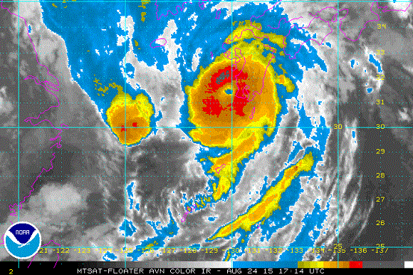
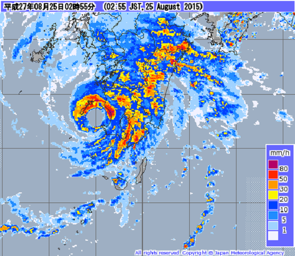
According to the Japan Meteorological Agency (JMA), Typhoon Goni is located at 31.3°N, 129.7°E as of 17:00 UTC, August 24, 2015, with a central pressure of 940 mb and maximum 10-minute sustained wind speeds of 176 km/h. After rapidly intensifying over the weekend, Goni has been fluctuating near its current intensity, with modest intensity changes associated with eyewall replacements. Typhoon Goni has maintained a good overall structure, including a clearly-defined eye and near symmetry of the cloud field (see Figure 1) and precipitation pattern (see Figure 2). The well maintained structure indicates that the typhoon is not experiencing much wind shear, even as it continues its recurvature toward the north and east. Nonetheless, imminent landfall on Kyushu Island should initiate a weakening trend for Typhoon Goni within the next few hours.
Figure 1. Infrared satellite image of Typhoon Goni at 17:14 UTC, August 24, 2015. (Source: NOAA)
Figure 2. Kyushu radar image of Typhoon Goni at 17:55 UTC, August 24, 2015. (Source: JMA)
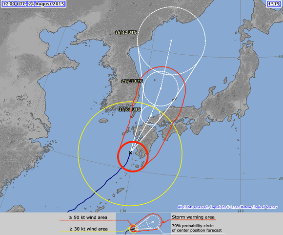
Typhoon Goni has generally been tracking toward the north and east around the western periphery of the subtropical ridge. This track is expected to continue with a bend towards the north for the next 24 hours (see Figure 3), after which Typhoon Goni is expected to make landfall near the borders of China, Russia, and North Korea. In the short term, the exact track of the typhoon during landfall on Kyushu Island will be critical for determining the impacts of storm surge in and around cities like Ichikikushikino. Areas to the right of the storm track are at greatest risk for storm surge, but all areas in and around the eyewall could experience damaging winds. Heavy rainfall and subsequent flooding are possible along Typhoon Goni’s track, but the relatively fast forward motion of the storm should help to prevent extreme rain-induced flooding.
Reported Impacts
Although Typhoon Goni has yet to make landfall on mainland Japan, the storm has already affected several islands, destroying more than 1,000 homes and leaving nearly 40 people dead or missing. Landslides killed more than a dozen people in Benguet, a mountainous province on the island of Luzon in the Phillippines. The province of Zambales, also located on the island, experienced deadly flash flooding caused by the typhoon’s heavy rains. On the Japanese island of Ishigaki, near Taiwan, strong winds and wind gusts have damaged utility poles, causing power outages for thousands of people.

Figure 3. Track forecast for Typhoon Goni, as of 17:00 UTC, August 24, 2015. (Source: JMA)