Typhoon Koppu 2015
Status: Closed
| Type of posting | Posting date(EST): | Summary | Downloads |
|---|---|---|---|
| Post Landfall 1 | 10/19/2015 1:00:00 PM |
|
|
| Pre-Landfall 1 | 10/16/2015 2:00:00 PM |
|
Post Landfall 1 | Summary
Posting Date: October 19, 2015, 1:00:00 PM
Widespread flooding, landslides, wrecked roads and bridges, downed trees, and power outages are reported as Typhoon Koppu moves out over the South China Sea after its painfully slow progress across Luzon in the Philippines. With the storm weakening and moving northward, the Japan Meteorological Agency (JMA) has downgraded Koppu (known as Lando in the Philippines) to a tropical storm. The Philippine Atmospheric, Geophysical, and Astronomical Services Administration (PAGASA) has removed or downgraded public storm warnings in some areas.
More than 60,000 people left their homes in advance of the storm, many of them to take shelter in evacuation centers. Only 11 deaths have been reported as yet, and this low toll is attributable to the typhoon’s track through sparsely populated mountain and coastal regions.
Meteorological Summary and Forecast
A notably slow-moving storm, Typhoon Koppu made landfall in Aurora Province near the town of Casiguran early Sunday morning local time. Rapid intensification occurred before landfall as the storm experienced very favorable environmental conditions (warm sea surface temperatures, high ocean heat content, and low vertical wind shear). According to the JMA, maximum sustained winds at landfall were approximately 185 km/h (115 mph) with a central pressure of 920 mb, making it a Category 4 storm on the Saffir-Simpson scale.

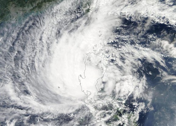
Figure 1. Koppu is now a disorganized system off the west coast of Luzon in the South China Sea. (Source: NOAA)
Since Sunday, Koppu has moved slowly across northern Luzon and is now centered just off the west coast in the South China Sea (Figure 1). The effects of land on the storm have produced a disorganized system with convection primarily located on the western side of the low-level circulation.
In the near term, Koppu is expected to move slowly northeastward over the sea, impacting the Philippines for the next couple days. Flooding and landslides will continue to be key concerns as many locations, particularly the west coast of northern Luzon, will see even more heavy rainfall.
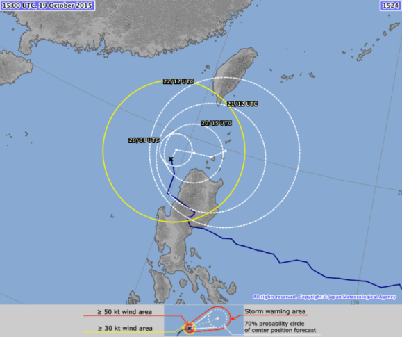
As it continues to move over open water, there may be some minor reintensification of the storm’s winds, but its very slow movement should upwell and mix colder water from below the sea surface, inhibiting significant reintensification. The forecast track in the medium range is for Koppu to move northeastward toward Taiwan or the Ryuku Islands of Japan (Figure 2).

Figure 2. Typhoon Koppu has now crossed the Philippine island of Luzon. (Source JMA)
Expected Impacts
Luzon is the world’s 15th largest island and northern Luzon experiences typhoons more frequently than any other part of the Philippines. The heavily populated Metro Manila region in the south, the nation’s economic and political center, was fortunately spared serious damage from Typhoon Koppu. Power outages however, impacted almost 10% of the Philippine’s population by Sunday afternoon.
Beyond Metro Manila there is little commercial or industrial activity in Luzon’s other regions, which are lightly populated and mountainous and/or agricultural. The mountainous northeastern section, for example, is the country's second largest producer of rice and its top corn producer, and the central plains are the nation's largest producer of rice. Bananas, mangoes, coconuts, pineapple, and coffee are also grown. Major crop damage is reported as a result of Koppu, with severe flooding of fields.
Typhoon winds can result in significant damage in the Philippines, but flooding is usually the principal cause of loss. So far, rainfall has been less than originally predicted by the numerical models, but Typhoon Koppu’s slow progress is still enabling it to deposit large amounts of precipitation.
Widespread landslides as well as riverine and flash floods are reported, and have led to road and bridge blockages. The city of Baguio has already received more than 400 mm (15.7 in) of rainfall, with much more expected. Nueva Ecija Province has experienced severe flooding, with reports of water depths head-high near Cabanatuan. The town of San Antonio in central Luzon and many other communities have been cut off. As water flows from the mountains it will likely overburden river systems downstream. There is also concern about some dams: one of the largest in the Philippines, Magat Dam, came close to its critical and spilling level on Sunday.
With moderate-to-heavy rains continuing, and with the flood risk far from over, some evacuated villagers are not yet being allowed home. Fishermen have been warned not to go to sea because of continued rough seas in the region, and schools in affected areas will remain closed through Tuesday.
Insurance Outlook
In the Philippines, lighter materials—such as wood frame with galvanized iron or aluminum roofs—are often used for residential buildings in rural areas. Some damage to such structures has already been reported. Typhoon and flood damage are usually covered together in the Philippines and are offered under separate fire policies with named perils extensions. Given that insurance penetration is typically no more than 10% to 20%, insured losses are not expected to be significant as a result of this event.