Typhoon Melor 2015
Status: Closed
| Type of posting | Posting date(EST): | Summary | Downloads |
|---|---|---|---|
| Post Landfall 1 | 12/16/2015 6:45:00 AM |
|
Post Landfall 1 | Summary
Posting Date: December 16, 2015, 6:45:00 AM
Meteorological Summary
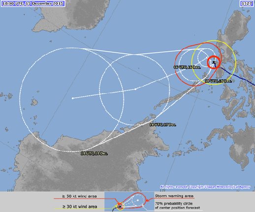
According to the Japan Meteorological Agency (JMA), Super Typhoon Melor, known locally as Nona, struck the Philippines on Monday, December 14, 2015, at around 3:00 UTC (11:00 a.m. local time) near Batag, Laoang, in the eastern Visayas. At the first of five landfalls across the archipelago of the Philippines, Melor had a central pressure of 935 mb and maximum 10-minute sustained wind speeds of 175 km/h (the equivalent of a Category 3 hurricane on the Saffir-Simpson Wind Scale). As of 18:00 UTC (2:00 a.m. local time) on December 15, 2015, Melor was at 13.4°N and 120.3°E and moving slowly west-northwest at 8 km/h, with a central pressure of 965 mb. Melor was still packing 10-minute sustained wind speeds of up to 130 km/h (the equivalent of a Category 1 hurricane) with maximum gusts as high as 185 km/h. Melor may have triggered storm surges of three to four meters according to some reports.
After its first landfall, Melor tracked generally westward and then west-northwestward. The storm eventually began to slowly weaken but was still a powerful typhoon as it traveled across the archipelago, making multiple landfalls. Melor made a second landfall at around 9:00 UTC (5:00 p.m. local time) on December 14, still with a central pressure of 935 mb and wind speeds reaching 176 km/h. A third landfall occurred around 12:00 UTC (8:00 p.m. local time) with a central pressure of 940 mb and winds of 167 km/h. The fourth occurred around 21:00 UTC (5:00 a.m. local time on December 15) on Banton Island with a central pressure of 955 mb and wind speeds of 148 km/h. A fifth landfall occurred on December 15 at around 3:00 UTC (11:00 a.m. local time) at Pinamalayan, Oriental Mindoro, with a central pressure of 950 mb and winds of 157 km/h.
Torrential rainfall has affected many regions due to Melor’s slow forward speed. In Oriental Mindoro, water is waist-high and still rising, trapping residents in their homes. Heavy rain up to 300 mm is forecast for Manila over the next few days. The Japan Typhoon Warning Center (JTWC) has predicted that Melor will still be at typhoon strength through December 17.
Figure 1. Typhoon Melor continues to move slowly westward after crossing the central Philippines. (Source: JMA)
Damage and Disruption
Melor has left a trail of damage and disruption across the northern and central Philippines just prior to the traditional nine-day Christmas vigil that is held in the country. Six central provinces have been severely affected with damage to buildings, agriculture, and infrastructure. Approximately 720,000 people were evacuated in Bicol Province in advance of Melor’s first landfall and the entire province of more than one million is without power. The evacuations are credited with a low number of fatalities; however, three deaths occurred in Northern Samar Province due to flooding and another occurred in Northern Samar from flying debris. Power outages also occurred in Bulan and the surrounding areas.
As Melor approached the Philippines, 40 domestic flights were cancelled and damage was sustained at Catarman Airport, whose terminal building roof was damaged. Ferry service was suspended, affecting about 8,000 ship passengers. All fishing boats were ordered to stay on land due to powerful waves from the approaching storm. Many schools and businesses were closed as well.
Heavy winds and rainfall will continue to impact several areas of the central Philippines for a few days. Manila has been affected by winds reaching approximately 60 km/h and is expected to be impacted by heavy rainfall of up to 300 mm.
Exposure in the Affected Areas of the Philippines
In the Philippines, lighter materials—such as wood frame with galvanized iron or aluminum roofs—are often used for residential buildings in rural areas. In contrast, urban residential structures are generally made of concrete block with metal roofs, although hollow concrete is also used. Masonry residences and high-rise apartments of steel construction can also be found in the cities. Masonry is often used for smaller commercial establishments, although the majority of all commercial and industrial buildings are reinforced concrete or steel. Building codes are not strictly enforced.
Structural damage is not expected for engineered structures, although well-constructed engineered buildings could have some damage to roofing and siding, especially to windward corners, rakes, and eaves. Some apartment building and shopping center roof coverings could experience moderate levels of damage, and wall siding may also experience some moderate levels of wind damage. Balconies and sliding glass doors, which are common in apartment buildings, increase the vulnerability to heavy winds.
One- and two-story buildings of mixed construction (concrete and wood) are common in Luzon. In Manila, high-rise commercial and apartment buildings are generally built to stricter code requirements. In addition, commercial and apartment buildings usually have stronger foundations than residential buildings, and these foundations provide stronger resistance to flood loads.
Buildings will respond differently to wind loads, depending upon their construction, height, and occupancy. The duration of damaging winds will also impact potential losses. Strong winds may peel back or blow off galvanized iron roofs and down trees and wooden utility poles, exposing live wires and causing power outages.
Landslides and flash floods could cause significant water and structural damage. Flood is much more damaging to the lower floors of multi-story buildings, making the commercial establishments on the first floor of many apartment buildings in the Philippines vulnerable to the flood conditions expected from Typhoon Melor.