Hermine
Status: Closed
| Type of posting | Posting date(EST): | Summary | Downloads |
|---|---|---|---|
| Landfall | 9/2/2016 8:05:00 AM |
|
|
| Pre-Landfall 1 | 9/1/2016 12:30:00 PM |
|
Landfall | Summary
Posting Date: September 2, 2016, 8:05:00 AM
Florida’s near 11-year hurricane drought ended at about 1:30 a.m. EDT Friday when Hurricane Hermine made landfall near St. Marks, Florida, 23 miles south of Tallahassee. The storm arrived as a Category 1 hurricane delivering maximum sustained winds of almost 80 mph, a significant storm surge, and flooding rains. After a few hours the system weakened to become a tropical storm as it moved steadily north-northeast into Georgia and it is forecast to gradually slow and weaken as it travels along the South-east coast toward New England, with the potential to disrupt the holiday weekend for many in its path.
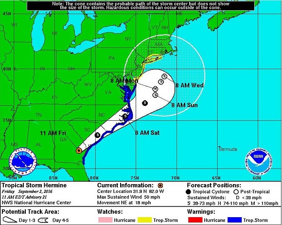
 The 5 Day Forecast Cone for Tropical Storm Hermine issued at 11 a.m. , Friday, September 2. (Source: NHC)
Surge, Flooding, and possible Tornadoes
Governor Rick Scott declared a state of emergency for 51 of the Florida's 67 counties and closed all state offices in those counties Mandatory evacuation notices were issued for communities on the water or in low-lying areas of the Gulf Coast. Although the storm has now passed inland, flooding rains continue in the Big Bend region and storm surge is still a concern in areas of onshore winds. The Big Bend is an area of marshy coast without barrier islands and is vulnerable to storm surge. At the time of high tide this morning (3 a.m.) the surge could have put 1 to 3 feet of water above ground level from the Aucilla River to Bonita Beach (including Tampa Bay) and from the Florida-Georgia line to Tidewater of Virginia. During the next 48 hours there is the possibility of life-threatening inundation at most coastal locations between the North Carolina/Virginia border and Bridgeport, Connecticut.
Tropical-storm-force winds extend up to 175 miles (280 km) mainly to the east of the center of the system, which is expected to produce from 5 to 10 inches of rainfall over much of northwest Florida and southern Georgia through Friday, and possibly as much as 15 inches in some areas. Hermine will continue to deliver heavy rain as it passes through the coastal Mid-Atlantic states from Virginia to New Jersey. The precipitation in Florida is heavy enough to cause life-threatening floods and flash floods.
Because tornadoes may be spawned in the outer rain bands of the storm system, tornado watches were in effect for many communities in the eastern edges of the north Florida/south Georgia regions until 8 a.m. EDT today. The risk of tornadoes will accompany Hermine as it moves inland and along the Mid-Atlantic coast.
Reported Impacts
Because of the storm surge and heavy precipitation, much of the damage expected from Hermine will be caused by flooding. Reported wind damage is typical of that from a Category 1 hurricane. There has been widespread tree damage leading to blocked roads and power outages. At the height of the storm there were 100,000 utility customers without power, but utility companies were able to start working to restore power at around 4:30 a.m. and this morning City of Tallahassee Utilities reported around 60,000 customers still without power. The town of Cedar Key was particularly hard hit due to a storm surge of up to 7 feet above the normal tide level.
Wind damage to non-engineered structures is likely to be limited to isolated instances of roof and wall cladding damage, and there may be isolated instances of minor damage to engineered structures. The Big Bend region is one of the most sparsely settled sections of the Florida coast.
The AIR Tropical Cyclone team will continue to monitor Hermine and provide updates if warranted.