Typhoon Nepartak
Status: Closed
| Type of posting | Posting date(EST): | Summary | Downloads |
|---|---|---|---|
| Post Landfall 1 | 7/11/2016 12:00:00 PM |
|
|
| Landfall | 7/8/2016 12:50:00 PM |
|
|
| Pre-Landfall 1 | 7/6/2016 10:50:00 AM |
|
Landfall | Summary
Posting Date: July 8, 2016, 12:50:00 PM
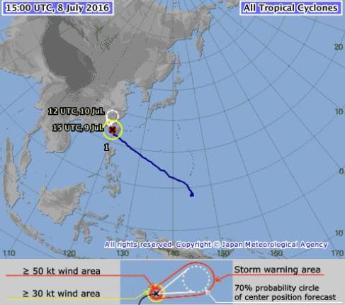
Typhoon Nepartak made landfall in Taiwan early Friday morning, local time, in the eastern county of Taitung, with a maximum 10-minute sustained wind speed of 167 km/h (104 mph) and central pressure of 940 mb. The strongest first typhoon since the Japan Meteorological Agency (JMA) began keeping records in 1951, Nepartak has caused three deaths and numerous injuries and drenched the eastern region, with one area receiving more than 550 mm (22 inches) of precipitation. Nepartak, which lost intensity while over Taiwan, is tracking across the Taiwan Strait and is expected to make landfall in the province of Fujian, China, Saturday morning local time.
Figure 1. Typhoon Nepartak after making landfall in Taiwan, crossing the island, and entering the Taiwan Strait. (Source: JMA)
Meteorological Summary and Forecast
Nepartak (the name refers to a Micronesian warrior) formed over the July 2-3 weekend south of Guam. By Monday, July 4, Nepartak reached typhoon status, becoming the first named storm in the western North Pacific basin of the 2016 season. Over the next two days, Nepartak intensified rapidly. By 20:00 CST (12:00 UTC) July 6, maximum sustained wind speed had reached 216 km/h (134 mph)—Category 4 on the Saffir-Simpson scale—and minimum central pressure had fallen to 900 mb; at that time, the storm was moving west-northwest at 30 km/h (19 mph). Before making landfall July 8 at about 5:50 CST (21:50 UTC on July 7), Nepartak slowed its forward speed as it began feeling the effects of Taiwan’s Central Mountain Range and passed over cooler ocean water, which combined to reduce wind speed to 167 km/h (104 mph) 10-minute sustained and increase central pressure to 940 mb.
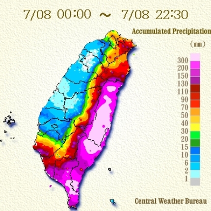
Landfall and Nepartak’s travel over Taiwan brought considerable rainfall, as predicted. As shown in Figure 2, most of the eastern region of the island received heavy precipitation. According to Taiwan's Central Emergency Operation Center, the highest rainfall amount—more than 550 mm (22 inches)—was recorded in Lioshi Shishan, Fuli Township, Hualien County.

Figure 2. Heavy precipitation from Typhoon Nepartak affected most of the eastern coast of Taiwan, reaching more than 300 mm (12 inches) in many areas. (Taiwan Central Weather Bureau)
Currently Typhoon Nepartak is tracking northwest toward the coast of China, with landfall predicted for Saturday morning, local time, in the province of Fujian. Although high wind gusts can be expected along coastal China, heavy rainfall accompanying the storm presents the greatest threat for the region, which has already received heavy rainfall in recent weeks.
Although Typhoon Nepartak will steer clear of the Philippines, the storm could intensify monsoon rains in the northern islands, which has prompted storm alerts in the Philippines and could result in the cancellation of some domestic flights.
Impacts
In advance of landfall, typhoon warnings were issued for counties on the eastern side of Taiwan and emergency shelters were set up throughout the region. In some remote, mountainous areas of eastern Hualien and Taitung counties, soldiers went door to door to encourage residents to head to shelters. According to the Central Emergency Operation Center, more than 15,000 people were evacuated, including residents of areas prone to landslides and workers at coastal fish farms. The defense minister deployed 4,400 soldiers around the island with amphibious vehicles and put 35,000 soldiers on standby to assist in evacuations and relief. According to news sources, food prices climbed rapidly as the storm approached the island and people stockpiled emergency supplies.
As the storm approached, severe storm waves—reportedly as high as 14 meters (46 feet)—resulted in commercial vessels and fishing boats being called to port and ferries canceling service. As weather worsened prior to landfall, hundreds of commercial flights also were canceled, including flights to and from Hong Kong by Cathay Pacific Airways and Dragonair, and trains and buses suspended operation. The Taiwanese government closed schools and government offices on Friday, as well as the financial markets.
The National Fire Agency reported three deaths from the storm, as well as numerous injuries from flying debris.
Reported Damage
High wind and wind-borne debris have caused destructive nonstructural damage to roof and wall claddings of many structures. Also, some commercial signage and billboards have been destroyed.
The high wind has also brought down power lines and uprooted trees, and reportedly motorcycles and cars have been overturned by the wind. The widespread power outages impacted 500,000 households, according to the Central Emergency Operation Center.
Businesses have been shuttered over much of the island, but damage has not been reported to the semiconductor plants in the south.