Typhoon Nepartak
Status: Closed
| Type of posting | Posting date(EST): | Summary | Downloads |
|---|---|---|---|
| Post Landfall 1 | 7/11/2016 12:00:00 PM |
|
|
| Landfall | 7/8/2016 12:50:00 PM |
|
|
| Pre-Landfall 1 | 7/6/2016 10:50:00 AM |
|
Pre-Landfall 1 | Summary
Posting Date: July 6, 2016, 10:50:00 AM
Over the weekend, Nepartak formed to the south of Guam and strengthened to typhoon status on Monday as the first named storm in the western North Pacific basin since mid-December 2015, setting a new record for the longest period (200 days) without tropical storm in the basin in 66 years.
Meteorological Summary
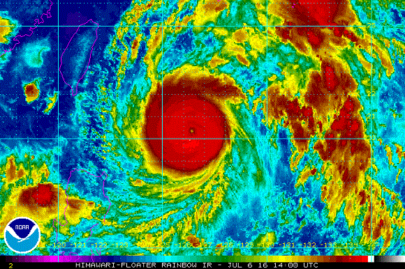
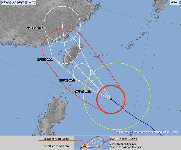
In just 48 hours, Nepartak rapidly intensified from a tropical storm to a typhoon with maximum sustained winds of 216 km/h (134 mph)—equivalent to a Category 4 hurricane on the Saffir-Simpson scale—and a minimum central pressure of 900 mb. At 12:00 UTC on July 6, 2016, it was located at 20.1°N, 127.0°E, to the southeast of Taiwan, in an area of high ocean heat content and low vertical wind shear, which has contributed to its rapid intensification. Satellite imagery shows a clearly defined eye and good upper-level outflow. It is expected to make landfall early Friday before turning northward toward eastern China.
The Northwest Pacific Basin produces more tropical cyclones each year than anywhere else in the world. On average, this basin spawns 29 tropical cyclones each year—20 of which reach typhoon status. This high frequency can be primarily attributed to the extremely large expanse of very warm water in the basin. In Southeast Asia (i.e., Guam, Hong Kong, Macau, the Philippines, Saipan, Taiwan, and Vietnam), Taiwan experiences the third-highest number of landfalling tropical cyclones annually—two per year on average—after the Philippines (first) and Vietnam (second).

Satellite image of Typhoon Nepartak. (Source: NOAA)
Forecast Conditions
Nepartak is forecast to continue intensification, potentially reaching the equivalent of a Category 5 hurricane. However, it is moving into an environment with cooler ocean temperatures than its current location, which is projected to contribute to weakening prior to landfall. Model consensus continues to point to a Taiwan landfall early Friday in Hualien or Taitung County. Nepartak is projected to bring torrential rains to Taiwan, with 100 mm of rainfall anticipated. Significant storm surge is also projected, as waves of up to 13 meters have already been reported at sea. However, inland penetration will be mitigated by the steep elevation along the island’s east coast. Flooding, landslides, wind-borne debris, coastal flooding, and damage or interruption to infrastructure (power, transportation systems, etc.) is expected.
Movement over the mountainous terrain of Taiwan will weaken the storm before it has a chance to turn northward and make a potential second landfall in eastern China on Saturday. There still exists considerable uncertainty in the location and intensity of the possible impact to China.

Track map of Typhoon Nepartak. (Source: JMA)
Emergency Preparations
Typhoon warnings have been issued for counties on the eastern side of Taiwan. An emergency center is set to be operational beginning Wednesday evening according to a spokesperson from the Taiwan Central Emergency Operation Center. Food prices in Taiwan have already begun to soar as people have started their own emergency preparations.
Exposure at Risk
While high winds typically cause the most tropical cyclone damage in other parts of the world, rain-induced flooding often causes the most damage in the Northwest Pacific Basin. Because tropical cyclones typically weaken rapidly upon interaction with the central mountain range in Taiwan and the eastern coast of the island is relatively unpopulated, heavy wind losses tend to be restricted to the east coast of Taiwan, including the areas of Taitung and Hualien. Strictly enforced building codes throughout the nation have resulted in structures with generally good wind resistance.
The country faces a serious threat from flooding, which is greatest along the southwestern mountains due to orographic lifting combined with occasional South China Sea monsoon-scale influences. The heavily urbanized areas of Taipei and Kaohsiung have sustained heavy flood damage during typhoons in the past, including the Tyhpoons Nari (2001) and Morakot (2009), both of which produced unprecedented levels of flooding.
Damage to property in Taiwan is generally distributed equally between wind and flood, but storm surge also has some appreciable contributions. Storm surge is significant in the west coast of Taiwan, and could heavily affect Taipei area and Kaohsiung area through Tamsui River and Love River. The deep bathymetry of the east coast minimizes storm surge risk on that side of the island.
Insurance Impacts
Residential take-up rates in Taiwan are low and commercial take-up rates vary. The population density along the eastern coast—the region most vulnerable to flood—is quite high. Such high concentrations of people increase the risk of loss of life and destruction of property. Industry impacts will depend on the direction and intensity of Typhoon Nepartak at landfall, as well as duration post-landfall.