Typhoon Nock-ten
Status: Closed
| Type of posting | Posting date(EST): | Summary | Downloads |
|---|---|---|---|
| Landfall | 12/27/2016 7:00:00 AM |
|
|
| Pre-Landfall 1 | 12/23/2016 6:00:00 AM |
|
Landfall | Summary
Posting Date: December 27, 2016, 7:00:00 AM
Super Typhoon Nock-ten made landfall on Christmas Day, December 25, 2016, in the municipality of Bato on the island province of Catanduanes in the Bicol Region of southern Luzon, Philippines. The landfall location of Catanduanes—one of the easternmost islands in the northern Philippines—was the hardest hit by the Category 5-equivalent storm, which wreaked havoc as it continued northwestward through the nation.
Meteorological Summary
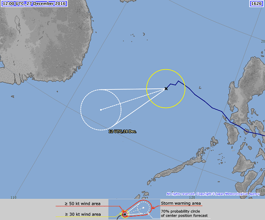
Nock-ten underwent a period of rapid intensification—due to low vertical wind shear and warm sea surface temperatures—from December 23–24 before reaching super typhoon strength and making landfall in Catanduanes with a minimum central pressure of 915 mb and maximum sustained winds of 215 km/h. Albay, Camarines Sur, Quezon, Marinduque, Oriental Mindoro, Occidental Mindoro, and Batangas Provinces were also directly impacted as Nock-ten made its way through the Philippines, steadily weakening as it interacted with land. Although not in the path of Nock-ten, Manila began to experience heavy rains from the system on December 26. Now a tropical storm, Nock-ten is currently moving southwestward over the South China Sea at 11 km/h with maximum sustained winds of 85 km/h and a minimum central pressure of 996 mb.

Track map of former Super Typhoon Nock-ten as of 12:00 UTC on December 27, 2016. (Source: JMA)
Nock-ten was the strongest tropical cyclone to occur anywhere on Christmas Day since 1960, and the most intense typhoon ever to make landfall in the Philippines or anywhere else in the Pacific basin so late in the season. Historically, the Philippines have experienced typhoon activity in every month, with peaks in July and November. Tropical Storm Tokage in November of this year was the last tropical cyclone to impact the Philippines. The last typhoon to make landfall there was destructive Super Typhoon Haima in October, which arrived only three days after Typhoon Sarika.
Because most tropical cyclones impact the Philippines along the relatively unpopulated eastern coast, wind risk is relatively low from a countrywide perspective; however, strong steering currents tend to slow storm movement through the region, making heavy precipitation common and elevating flood risk.
Reported Impacts
Approximately 420,000 people abandoned their Christmas plans for shelter or higher ground. PAGASA reported storm surge heights of nearly three meters (10 feet) in coastal areas. More than 300 flights were delayed or rescheduled. According to the National Disaster Risk Reduction and Management Council, 11,476 passengers, more than 1,000 cargo ships, and multiple other vessels have been stranded in various ports in the region. One cargo ship sank off the coast of Batangas Province, where a search for 18 missing people is underway. At least seven deaths have been reported from Nock-ten, including some of the missing people from the sunken cargo ship.
The military has reported that the coconut plantations in Virac in eastern Catanduanes, the primary industry there, has been completely devastated and could take 5–10 years to recover. The Department of Energy said strong winds uprooted trees and knocked down power lines in all but one of the six provinces in the Bicol Region, and heavy rains submerging several low-lying towns. Camarines Sur province was designated a disaster zone to facilitate the distribution of resources and funding.
Exposure at Risk
Luzon is the world’s 15th largest island, and northern Luzon experiences typhoons more frequently than any other part of the Philippines. The Metro Manila region, at the northern tip of southern Luzon, is the Philippine’s economic and political center; little commercial or industrial activity occurs in country’s other regions, which are lightly populated and mountainous and/or agricultural.
The majority of insurable properties in the Philippines are of reinforced masonry, concrete, and steel construction. Urban residential structures are generally made of concrete block with metal roofs, although hollow concrete is also used. Masonry residences and high-rise apartment buildings of reinforced concrete construction can also be found in the cities; in Manila, high-rise apartment buildings are generally built to stricter code requirements.
Most commercial and industrial buildings are reinforced concrete or steel, although masonry is often used for smaller commercial establishments. Building codes are not strictly enforced outside of Manila. Commercial and apartment buildings usually have stronger foundations than residential buildings, which provide stronger resistance to flood loads. Lighter materials—such as wood frame with galvanized iron or aluminum roofs—are often used for residential buildings in rural areas.
The Bicol Region, the southern part of Luzon, is home to many cultural landmarks as demarcated by the National Historical Commission of the Philippines (NHCP). The age of these structures could make them more vulnerable to wind and flood damage.
Industry Impacts
Typhoon-related wind and flood damage are usually covered together in the Philippines. Reports of significant wind damage have been relatively scarce, but the impacts of flooding on exposures will continue to surface. Landslides and flash floods could cause significant water and structural damage. Flood is much more damaging to the lower floors of multi-story buildings, making the commercial establishments on the first floor of many apartment buildings in the Philippines vulnerable to flood conditions. However, given that insurance penetration is typically no more than 10% to 20%, insured losses are not expected to be significant as a result of this event.
Forecast Track and Intensity
Nock-ten is expected to accelerate southwestward while weakening due to the infusion of cooler, drier air, and then dissipate over the South China Sea on December 28.