Typhoon Sarika
Status: Closed
| Type of posting | Posting date(EST): | Summary | Downloads |
|---|---|---|---|
| Post Landfall 1 | 10/18/2016 9:45:00 AM |
|
|
| Landfall | 10/17/2016 10:30:00 AM |
|
|
| Pre-Landfall 1 | 10/14/2016 2:00:00 PM |
|
Post Landfall 1 | Summary
Posting Date: October 18, 2016, 9:45:00 AM
After hitting the northern Philippines on the morning of October 16 as a Category 3-equivalent storm, Sarika—the 21st typhoon of 2016 in the northwest Pacific Basin—made its way toward the island province of Hainan in southeast China, where it made landfall in the city of Wanning at 9:50 this morning local time (1:50 UTC) as a Category 2-equivalent storm with JMA-estimated 1-minute sustained winds of 99 mph. Sarika has since weakened and become a tropical storm but not before bringing heavy rains to both the northern Philippines—only the second typhoon to hit the area this year—and Hainan Province. About 8 inches of rain had fallen on Haikou, the capital city of Hainan, by midday local time, and the city of Qionghai in Hainan Province has recorded more than 10 inches of precipitation in the 24-hour time period between yesterday early afternoon and early afternoon today local time. This is roughly half the precipitation Sarika brought to the Philippines where more than 20 inches of rain fell on the capital city of Catanduanes Province, Virac, and on the nearby town of Daet.
Reported Impacts
Ahead of Sarika’s approach, Hainan’s preparations included evacuating tens of thousands of people and closing schools in eight counties as well as tourist sites. High-speed train service connecting the province’s cities was suspended, and hundreds of flights to and from Haikou Meilan International Airport were canceled yesterday and into this morning. Trees have toppled and store signs have been blown away.
Exposure at Risk
Houses in coastal regions of southern and southeastern China are commonly confined masonry or reinforced concrete with clay tile roofs, which should perform fairly well in the face of Category 2-equivalent typhoon winds.
In contrast, urban apartment buildings tend to be mid- or high-rise structures, many of which have commercial establishments on the ground floor; mid-rise buildings are often confined masonry while high-rises tend to be reinforced concrete. Apartment buildings, which have become common in recent years, are made largely of reinforced concrete and confined masonry. Better-engineered apartment buildings are common, although they could experience minor nonstructural damage, especially to roofs and wall claddings.
Commercial and industrial structures still vary widely across China, ranging from poorly constructed low-rise masonry structures to well-maintained mid- and high-rise reinforced concrete buildings constructed to strict code standards. Generally, commercial and industrial buildings are more resistant to wind and water damage than residential buildings.
>With high population density along the southeast coast of China, many homes and businesses are at risk. As is often the case with China typhoons, flooding is a major concern; with much of the population located near waterways and along the coast, many homes and businesses are at risk.
Forecast and Intensity
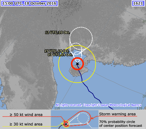
Sarika is expected to head to the border between mainland China and Vietnam and make landfall as a tropical storm before moving inland. Central Vietnam has already experienced heavy rains that have caused severe flooding for the past few days, resulting in 31 deaths and the inundation of thousands of homes. Sarika is not expected to make landfall in this part of Vietnam, if it makes landfall in this country at all.

Figure 1. Two-day track for Typhoon Sarika, as of 15:00 UTC October 18, 2016. (Source: JMA)
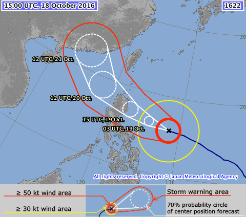
Close behind Sarika is Haima, which is expected to be the third typhoon this year and the second in four days to make landfall in the northern Philippines. Haima is located at 15.4° North and 128.3° East, roughly 600 miles east of the Philippines, with a minimum central pressure of 905 and maximum wind speed of 145 mph (1-minute sustained), making it a Category 4-equivalent storm. In addition to damaging winds, Haima is expected to bring flooding caused by storm surge and heavy precipitation, as well as landslides to northern Luzon, then pass south of Taiwan, which has had two typhoon landfalls—Nepartak in July and Megi in September—as well as two strong bypasses from Meranti and Malakas already this year. After passing Taiwan, a weakened Haima is forecast to make landfall in southeast China on Friday local time.

Figure 2. Three-day track for Typhoon Haima, as of 15:00 UTC October 18, 2016. (Source: JMA)