Cyclone Debbie
Status: Closed
| Type of posting | Posting date(EST): | Summary | Downloads |
|---|---|---|---|
| Landfall | 3/28/2017 11:00:00 AM |
|
Landfall | Summary
Posting Date: March 28, 2017, 11:00:00 AM
Cyclone Debbie roared ashore at Airlie Beach on the Queensland, Australia, coast on Tuesday, March 28, 2017, shortly after 12:00 noon AEST (02:00 UTC). The most powerful storm to strike Australia since Cyclone Yasi destroyed Queensland resorts, homes, and crops in 2011, Debbie landed as a Category 4 storm on the Australia Bureau of Meteorology (BOM) intensity scale (similar to a Category 3 Atlantic hurricane), with wind gusts as strong as 260 km/h (160 mph) and heavy rain. A large, slow-moving storm, Debbie missed high tide by a couple of hours, sparing Bowen, Mackay, and other coastal towns the high storm surge that had been predicted. Debbie deintensified quickly after reaching land and by the end of the day had been downgraded to a Category 2 cyclone on the BOM scale.
Moving at a crawl over the warm waters of the Coral Sea, Cyclone Debbie had strengthened from a tropical low five days before landfall. Prior to reaching Queensland, Debbie tore through Whitsunday Islands, a popular tourist destination, damaging resorts, beaches, and boats. On Hamilton Island, a maximum sustained 1-minute wind speed of 220 km/h (136 mph) was recorded.
Debbie is the first tropical cyclone of hurricane strength to affect Queensland since Tropical Cyclone Marcia in 2015. In late January this year, a record was set for the longest period without a hurricane-strength storm (74 mph or greater winds) in the three major Southern Hemisphere basins, 280 days.
Within hours of Cyclone Debbie landfall, the Insurance Council of Australia declared the storm a catastrophe, which can facilitate settling claims.

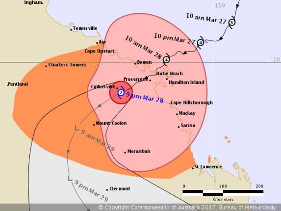
Typhoon Debbie track at 8:56 p.m. AEST (10:56 UTC) on March 28, 2017, about 9 hours after landfall on Airlie Beach, in Queensland, Australia. (Source: Australia Bureau of Meteorology)
Reported Damage and Disruption
Prior to landfall, Australian authorities urgently urged the tens of thousands of people in the path of the storm to evacuate, particularly residents and visitors in low-lying coastal areas at risk from the expected storm surge and from flash flooding. Throughout the region, schools closed and shelters opened. Coal mine operators in Debbie’s projected path shut down, marine terminals closed, and the Townsville Airport suspended operations. Tourist resorts along the coast have been impacted since the weekend, with many guests leaving and others moving to lodgings away from the water.
Cyclone Debbie’s powerful winds and heavy rain exacted the damage expected throughout the impacted coastal region: downed trees, damaged roofs and gutters, broken windows, and boats ripped from moorings. Flooded streets have resulted in damage to vehicles as well as residential and commercial property. Caravan (trailer) parks have reported substantial damage. Power outages occurred in a number of areas from Bowen south to Mackay, and communication to some communities has been affected. The heavy rain, which could result in flash flooding, is predicted to continue this week, with 24-hour rainfall totals of 100–200 mm (6–8 inches) expected and up to 500 mm (20 inches) possible, which could result in major river flooding. The Bowen region boasts a sizable agricultural industry, and farmers remain uncertain of the impact on the tomato, sugar, rice, and capsicum (pepper) crops.
Exposure at Risk
Residential buildings in Australia are mostly single-family homes, with primarily apartments and condominiums in larger cities. Most of Australia’s residential buildings are either wood frame or masonry, many with brick veneer, and most often with metal roofs. Most homes are low-rise, so wind damage tends to impact building envelopes (roofs and exterior walls).
The commercial and industrial building stock in Australia is predominantly concrete and steel. Large commercial buildings, especially mid-rise and high-rise structures, tend to be engineered and are therefore more resistant to wind damage than smaller buildings. Windows and cladding on engineered structures do risk impact damage from airborne debris, of course.
Strong building codes have been in place across north Queensland since devastating Cyclone Tracy in 1974, improving the resilience of structures built to code. For those structures that have been built to code, the structural building practices and requirements set down by the code will help mitigate the effects of high winds and associated debris.
With Cyclone Debbie’s high winds, structural damage can be significant, notably for older buildings. Rooftops remain particularly vulnerable, although windows and cladding on engineered structures also could be damaged by impact from debris. The high winds also can result in overturned caravans (trailers). Some structures in low-lying coastal areas are expected to experience storm surge damage. Given the heavy rain predicted, some structures in the inland area could experience some precipitation-induced flood damage.
Forecast Track and Intensity
Cyclone Debbie will continue to deintensify and is expected to weaken to a Category 1 storm by early Thursday, March 29, local time. Debbie’s storm track should turn south and eventually southeast as the storm dissipates.