Hurricane Franklin
Status: Closed
| Type of posting | Posting date(EST): | Summary | Downloads |
|---|---|---|---|
| Landfall | 8/10/2017 9:00:00 AM |
|
Landfall | Summary
Posting Date: August 10, 2017, 9:00:00 AM
Franklin made its second landfall near the town of Lechuguillas about 176 miles east of Mexico City shortly after midnight local time (05:00 UTC) on August 10, 2017, as a Category 1-equivalent storm, with maximum sustained 1-minute winds of 140 km/h and a minimum central pressure of 988 mb. While moving westward and weakening the storm is delivering heavy rainfall to the region.
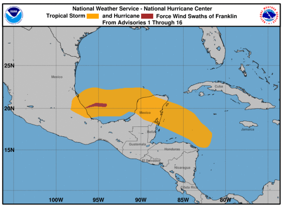
Wind history for Hurricane Franklin from NHC wind advisories 1 through 16. (Source: NHC)
Meteorological Summary
Franklin is the Atlantic Basin’s first hurricane to form this year and the sixth named storm. The storm made its first landfall in Mexico as a tropical storm near Pulticub, which is roughly 180 miles south-southwest of Cozumel, at 11 p.m. local time (18:00 UTC) on Monday, August 7. Franklin brought heavy rains which caused flooding in parts of the Yucatan Peninsula, including the city of Campeche.
After strengthening over the Bay of Campeche, Franklin developed into a Category 1 hurricane before it made landfall, but weakened to a tropical storm a few hours afterward. It may deliver up to 8 inches of rainfall as it passes across eastern Mexico today, with as much as 15 inches possible in some locations.
Reported Impact
As well as tree and property damage from high winds, Franklin is likely to trigger both flash floods and mudslides, to which the region is vulnerable. In addition, storm surge to the north of the landfall could reach 6 feet and bring with it large and destructive waves.
It was just over one year ago when Hurricane Earl impacted Mexico. The deadliest Atlantic hurricane in more than a decade, Earl brought heavy rains as it crossed the Yucatan Peninsula.
Exposure at Risk
The most concentrated exposures in Mexico are in urban centers, which consist mainly of capital cities and resort towns. Urban centers have a high density and diversity in building types, from residential single-story houses to high-rise apartments to hotels to religious and cultural centers. However, the rate of rapid growth within Mexican cities is exacerbating already highly concentrated areas in a way that is increasing hazard risk. Poor, rural families are migrating to cities at high rates and building poorly designed structures along city outskirts. These structures can be feebly made and situated in precarious locations, such as on hillsides. Development of urban slopes increases the risk of flooding in the surrounding low-lying areas, which often corresponds to the urban centers.
The predominant construction types for insured residential buildings in Mexico are masonry and concrete. Masonry buildings can better resist the wind uplift load than wood frame buildings, due to their mass. For apartments, reinforced masonry or concrete is used predominantly. High-rise apartment buildings, in contrast, are chiefly constructed of reinforced masonry, reinforced concrete, or steel, and wind damage to these buildings is typically restricted to nonstructural components, such as windows, wall sidings, and roofs. Commercial building stock is heterogeneous, varying from poorly constructed low-rise masonry structures to well-maintained steel buildings, although concrete and masonry are the main construction types; wind damage to commercial buildings is usually restricted to nonstructural components, such as windows and wall sidings.
Building contents, including system equipment stored in basements or on first floors, are vulnerable to flood damage. Inland exposure concentrations are at risk from precipitation-induced flooding due to heavy rainfall, which may collect in low-lying areas and cause river- and streambeds to overflow and flood surrounding regions.
Forecast Track and Intensity
Franklin is currently moving westward at about 15 mph, weakening as it goes. According to the 11 a.m. EDT advisory issued by the National Hurricane Center (NHC) it has now dissipated and no further advisories will be issued. Continuing precipitation, however, will make flooding and landslides possible in its wake as far west as Mexico City through Friday. Franklin’s remnants will pass into the Pacific Ocean, where the NHC is watching for possible re-development.