Hurricane Irma
Status: Closed
| Type of posting | Posting date(EST): | Summary | Downloads |
|---|---|---|---|
| Post Landfall 1 | 9/15/2017 9:30:00 AM |
|
|
| Landfall | 9/10/2017 10:35:00 PM |
|
|
| Pre-Landfall 2 | 9/8/2017 10:00:00 PM |
|
|
| Pre-Landfall 1 | 9/7/2017 11:30:00 AM |
|
Pre-Landfall 1 | Summary
Posting Date: September 7, 2017, 11:30:00 AM
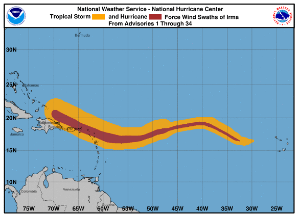
Category 5 Hurricane Irma, one of the most powerful Atlantic tropical cyclones on record, has devastated a string of Caribbean islands, is currently impacting the Dominican Republic and Haiti, and is forecast to turn northward on Saturday toward Florida. By every measure, Irma is a huge and powerful storm system; its 300-mile diameter is twice as wide as Florida and is roughly equivalent to the area of the state. At its peak, it sustained 185 mph winds for 36 hours, and has maintained intensity above 180 mph longer than any storm in Atlantic history.

Hurricane Irma’s wind history as of 11 a.m. ET on September 7, 2017. (Source: NHC)
The center of Hurricane Irma is currently over water, moving along the mountainous northern coast of the Dominican Republic and Haiti. It was located about 75 miles north of Puerto Plata in the Dominican Republic at 11 a.m. ET on September 7. The storm may deposit 10 to 15 inches of rain today, likely leading to flash floods and landslides in the region.
Hurricane Irma formed from a tropical wave off the western coast of Africa first noted on August 26. Benefiting from almost ideal hurricane-forming conditions—warm sea surface temperatures and a near total absence of wind shear—Irma intensified rapidly, becoming a Category 2 hurricane within 24 hours of formation and a Category 3 soon after. It became a Category 5 hurricane on September 5 and attained its peak intensity and made landfall on the northern coast of Barbuda on September 6.
Exposure at Risk
Caribbean residential building stock is dependent on exposure location—urban or rural—and has regional differences. Older urban structures across the Caribbean exhibit a wide variety of construction materials, but the majority of new residential buildings are made of masonry, reinforced concrete, or both.
Most commercial structures in the Caribbean are low- to mid-rise, comprising one to six stories. Small apartments, hotels, offices, and other low-rise commercial properties are usually masonry, or reinforced or block concrete. As with residential buildings, there is regional variability. Across the Caribbean, there is a wide range in building code type, use, and enforcement.
The “Bunker” style is a concrete building type unique to Puerto Rico that is used for both residential and non-residential structures across the island. Some single-family homes and apartments employ the bunker style, as do various federal court buildings, prisons, and selected neighborhood commercial structures. Bunker buildings have walls comprised of reinforced concrete, often combined with reinforced masonry. Bunkers have either small “Miami” windows, or highly wind-resistant windows. Bunkers became more prevalent in Puerto Rico following Hurricane Hugo in 1989.
There are diverse roofing practices across the Caribbean. In the Netherlands Antilles and Cayman Islands, shingle and tile roof coverings are widespread. In contrast, concrete slabs are more frequently used in Puerto Rico and limestone slate roofs are typically used in Bermuda. Yet, the most common type of roofing used across the Caribbean for residential structures is timber with metal roof covering that has been applied with corrugated or standing seam.
For the smaller Caribbean islands, such as the Bahamas and all the Leeward and Windward Islands, the majority of the exposures are on the coast. On the larger islands, however, some inland cities can also face significant hurricane risk, especially from precipitation-induced flooding. Because of Irma’s great size and intensity, damage is likely to occur across a wider zone than with more typical hurricanes and may be more akin to that from a tornado in some places.
Reported Damage
Hurricane Irma has left a trail of catastrophic devastation in its wake. In Barbuda, 90% of structures are reportedly destroyed and half of the population of 1,800 has been rendered homeless. Major damage to homes and infrastructure has also been reported in Anguilla. In St. Martin, 95% of structures have been destroyed, according to a local official. Significant damage to homes, businesses, and infrastructure has been reported in the British Virgin Islands, and a State of Emergency has been declared in the U.S. Virgin Islands. Puerto Rico experienced flash flooding and widespread power outages after Irma passed just north of the island on the afternoon and evening of Wednesday, September 6. The electrical power authority in Puerto Rico has already predicted that the loss of power may last for as many as six months.
Forecast Track and Intensity

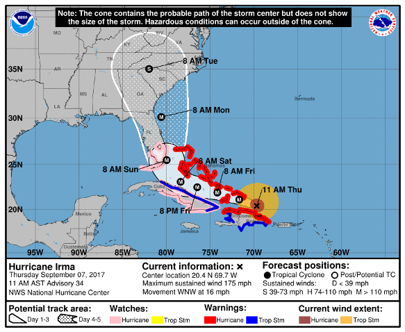
Track map for Hurricane Irma issued at 11 a.m. E on, September 7, 2017. (Source: NHC)
Irma is currently forecast to continue as a Category 5 hurricane through the Turks and Caicos, and Southern Bahamas, where a storm surge of 15 to 20 feet (4.5-6m) is expected. The storm system is likely to stay south of the Central Bahamas and just north of Cuba, where hurricane or tropical storm conditions also are possible. Late on Saturday, Irma is forecast to begin a fairly sharp turn northward, making an initial landfall in the Upper Keys as a strong Category 4 hurricane early Sunday morning. No further significant interaction with land is anticipated before the expected landfall in South Florida.
AIR's tropical cyclone team continues to monitor Hurricane Irma and will issue updates as warranted.