Hurricane Nate
Status: Closed
| Type of posting | Posting date(EST): | Summary | Downloads |
|---|---|---|---|
| Landfall | 10/8/2017 9:30:00 AM |
|
|
| Pre-Landfall 2 | 10/7/2017 8:00:00 AM |
|
|
| Pre-Landfall 1 | 10/6/2017 8:00:00 AM |
|
Landfall | Summary
Posting Date: October 8, 2017, 9:30:00 AM
The fourth hurricane to make landfall in the U.S. in the past two months, Nate came ashore near the mouth of the Mississippi River at approximately 7:00 PM CDT on Saturday, October 7, according to the National Hurricane Center (NHC). At Category 1 strength, Nate brought winds of up to 85 mph and torrential rains to the coastal region of Mississippi and Alabama. The storm made a second landfall at Category 1 strength approximately 5 miles west of Biloxi, MS, at about 12:30 AM CDT this morning.
The NHC had warned of a possible storm surge of 7 to 11 feet. Fortunately, due to the storm’s compact size and relatively fast forward speed, the highest recorded surge levels topped off at between 4 and 5 feet. Heavy rainfall between 3 and 6 inches (10 inches in some isolated locations) across a large swath of the South is expected as Nate, now downgraded to a tropical depression and rapidly weakening, continues to track inland.
Reported Damage
Ahead of Nate’s arrival, the governors of Louisiana, Mississippi, Alabama, and Florida declared states of emergencies, while President Trump issued a federal emergency declaration for Mississippi and Louisiana.
As of early this morning, more than a quarter of million households in Mississippi, 50,000 households in Alabama, and 3,000 households in Florida are without power.
Reported structural damage to buildings has been limited thus far, as expected given Nate’s wind speeds and the stringency of building codes on the Gulf Coast. There were also very few reports of flood damage from Nate’s surge. On Dauphin Island in Alabama, officials reported submerged roads, houses, and cars.
Some structural damage to homes and businesses is possible, as well as a weakening of some foundations caused by heavy rain and surge, with some homes removed from their foundations entirely. Roads and bridges, including escape routes, could also get washed out, leading to closures.
Nate’s winds may cause damage to roofing and siding materials, porches, awnings, carports, and sheds. Mobile homes, especially those that are unanchored, could experience significant wind damage, and unsecured, lightweight objects could become airborne and cause damage as projectiles, particularly to windows, which could allow water into structures. Large trees could snap or be uprooted, falling on power lines and causing outages. Small craft could break away from their moorings and become beached or damage other craft. Damage to marinas, docks, boardwalks, and piers in the area affected is also possible.
Offshore Impact
Offshore oil and gas operators in the Gulf of Mexico evacuated platforms and rigs in the path of Hurricane Nate. According to a news release issued on October 7 by the Federal Bureau of Safety and Environmental Enforcement (BSEE), personnel have been evacuated from 302 production platforms, or about 41% of the 737 manned platforms in the Gulf of Mexico. Personnel have been evacuated from 13 of the 20 non-dynamically positioned rigs in the Gulf of Mexico. Sixteen dynamically positioned rigs have moved off location. Approximately 92% of the current daily oil production and approximately 77% of the daily natural gas production in the Gulf of Mexico has been shut-in. No physical damage has yet been reported to offshore assets.
Forecast
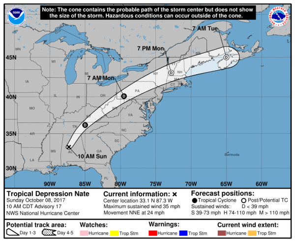
As of 10:00 AM CDT, Nate is a tropical depression with maximum sustained winds of 35 mph. It is currently located in Alabama approximately 40 miles southwest of Birmingham. The storm is moving north-northeast at near 24 mph and is expected to rapidly weaken to a post-tropical system on Monday or Tuesday.
Three-day forecast for Tropical Depression Nate