Typhoon Doksuri
Status: Closed
| Type of posting | Posting date(EST): | Summary | Downloads |
|---|---|---|---|
| Landfall | 9/15/2017 5:21:00 AM |
|
Landfall | Summary
Posting Date: September 15, 2017, 5:21:00 AM
Vietnam’s most powerful typhoon in a decade made landfall in Ha Tinh Province at about noon local time on Friday, September 15. Typhoon Doksuri was maintaining maximum sustained winds of 170 km/h (106 mph, 1-minute sustained) at landfall, and a storm surge of up to 2 meters (6.5 feet) was anticipated by Vietnam's disaster prevention committee. Coastal provinces in central Vietnam from Nghe An to Quang Tri were directly impacted by the storm system.
More than 80,000 people in five central provinces were evacuated from coastal locations in advance of the storm’s arrival and fishermen dragged their boats into the streets of coastal towns to prevent them from being lost. Four fishing boats are known to have sunk as they were making their way back to land ahead of the storm. At least 46 flights between the capital, Hanoi, and Ho Chi Minh City in the south were canceled.
Meteorological Summary
The climatology of typhoon activity for Vietnam is influenced by the fact that it is at the western edge of the Northwest Pacific Basin. About four typhoons make landfall in Vietnam on an annual basis, but they tend to be mainly tropical storms or very weak typhoons and activity decreases toward the south. The relatively frequent but weak activity is the result of warm water from the South China Sea being able to support typhoon genesis. In almost all cases there is either not enough space or insufficient dynamics (because of its southwestward location) to allow significant intensification prior to landfall. Despite the lack of strong winds, there is typically a lot of precipitation. Damage from flood is the primary threat from typhoons for Vietnam.
Typhoon Doksuri formed to the west of the Philippines (where it was known as Typhoon Maring) and slightly intensified ahead of its landfall there as a tropical depression on September 12. It caused massive floods in Luzon and other parts of the Philippines and resulted in at least five deaths.
Exposure at Risk
In Vietnam, the majority of residential structures are reinforced concrete low- to mid-rise buildings. However, there is still a large portion of residential structures that are unreinforced masonry buildings, especially those that are low-rise. These masonry buildings usually fail to follow local building codes and are constructed without proper supervision, which makes them vulnerable to natural hazards, such as typhoons. Wood frame is rarely found in residential buildings throughout the region, but still widely used in agricultural buildings Vietnam. The primary materials for commercial use buildings in Southeast Asia are reinforced concrete and steel, although there is still a significant portion using masonry in Vietnam.
Reported Impacts
Ha Tinh Province, where the storm made landfall, and neighboring Quang Binh Province experienced the worst of the storm. Widespread power outages and damage to roofs, trees, and billboards are reported. In Quang Binh, about 200,000 houses are reported flooded, 5,000 have lost their roofs, and 20 collapsed. Flooding is also reported in other locations. The storm narrowly missed Vietnam's most important coffee-growing areas and rice farmers rushed to harvest their crops before Doksuri arrived, some of them with assistance from military personnel. In Thừa Thiên–Huế province, however, 583 ha of rice could not be harvested and are expected to be lost.
Insurance in Vietnam
Vietnam is currently ranked as the 52nd largest insurance market in the world and the 57th largest non-life (P&C) market. Non-life and health insurance penetration in Vietnam lags significantly behind comparable countries. In 2014 non-life (P&C) market premium represented 0.54% of GDP, for example, compared with 1.13% in China and 1.37% in Thailand.
Forecast Track and Intensity
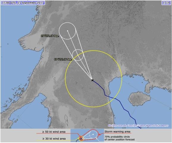
The typhoon has already passed into neighboring Laos, where it is expected to weaken and dissipate in the remote hills of the eastern part of the country early Saturday. Precipitation from Doksuri may cause major flooding in central Vietnam over the next two days,and flash flooding and landslides in the provinces of Hoà Bình, Sơn La, Thanh Hoá, and Thừa Thiên–Huế.

Track map for Typhoon Doksuri issued at 15:00 UTC, Friday, September 15, 2017. (Source: JMA)