Helene
Status: Closed
Pre-Landfall SSEs #1 | Summary
Posting Date: September 24, 2024, 10:00:00 AM
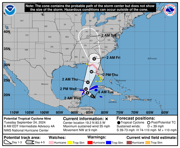
As of 8:00 am EDT, Potential Tropical Cyclone Nine was located 150 miles west of Grand Cayman, with estimated maximum 1-minute sustained winds of 35 mph. The forecast calls for the storm to become Tropical Storm Helene later today, and continue to strengthen, perhaps quite rapidly, as it moves toward a likely landfall along the panhandle or Big Bend region of Florida late in the day on Thursday. Given the storm’s orientation and uncertainty in the track forecast, major impacts in the Tampa area cannot be ruled out yet. Helene is currently projected to each major hurricane status prior to landfall on the Gulf coast.

ALERT™ subscribers can download similar stochastic event (SSE) IDs for soon-to-be-named Helene from the Downloads tab of this posting on the ALERT website. Compatible with Touchstone® and Touchstone Re™, the SSEs were selected based on the event’s projected key meteorological parameters at landfall, in particular storm track, minimum central pressure, estimated winds, forward speed, and landfall angle. They were selected primarily for impacts in Florida and can also be used to broadly capture potential storm impacts in Georgia and Alabama.
The Verisk ALERT team will issue updated similar stochastic events for this event on Wednesday, September 25th, by around 10:00 am EDT, and will continue to do so each day through landfall. In the meantime, please contact your Verisk representative with any questions about this event.
Pre-Landfall SSEs #1 | Downloads
Posting Date: September 24, 2024, 10:00:00 AM
The information provided herein is strictly confidential and is solely for the use of Verisk clients; disclosure to others is prohibited.
Similar Stochastic Event IDs
Note: These lists give event IDs taken from our stochastic catalog that have similar characteristics as the current event.