Helene
Status: Closed
Pre-Landfall SSEs #2 | Summary
Posting Date: September 25, 2024, 10:00:00 AM
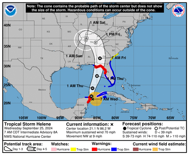
As of 7:00 am CDT, Tropical Storm Helene was located about 100 miles west-southwest of the western tip of Cuba, with maximum estimated 1-minute winds of 70 mph and a minimum central pressure of 979 mb. Helene is forecast to pass the Yucatan peninsula today on its way into the Gulf of Mexico, where significant strengthening is expected. The current National Hurricane Center forecast brings Helene across the Florida panhandle south of Tallahassee late Thursday as a Saffir-Simpson category 3 storm. A Hurricane Warning is in effect from Anclote River to Mexico Beach, Florida.
ALERT™ subscribers can download similar stochastic event (SSE) IDs for Helene from the Downloads tab of this posting on the ALERT website. Compatible with Touchstone® and Touchstone Re™, the SSEs were selected based on the event’s projected key meteorological parameters at landfall, in particular storm track, minimum central pressure, estimated winds, forward speed, and landfall angle. They were selected primarily for impacts in Florida and can also be used to broadly capture potential storm impacts in Georgia and Alabama.

The Verisk ALERT Team is monitoring impacts from Helene along the Yucatan peninsula, but no ALERT postings specific to this are currently planned. We will issue updated similar stochastic events for U.S. impacts from this event on Thursday, September 26th, by around 10:00 am EDT. In the meantime, please contact your Verisk representative with any questions about this event.
Pre-Landfall SSEs #2 | Downloads
Posting Date: September 25, 2024, 10:00:00 AM
The information provided herein is strictly confidential and is solely for the use of Verisk clients; disclosure to others is prohibited.
Similar Stochastic Event IDs
Note: These lists give event IDs taken from our stochastic catalog that have similar characteristics as the current event.