Helene
Status: Closed
Sunday 9/29 Update | Summary
Posting Date: September 29, 2024, 1:00:00 PM
Hurricane Helene has caused extensive and catastrophic flooding across the southeast U.S. since Friday. More than 60 deaths have been reported across the impacted states of Florida, Georgia, South Carolina, North Carolina, and Virginia.
Impacts from Helene Across the Southeast U.S.
In Florida, wind and storm surge were the primary drivers of loss. Keaton Beach was especially hard hit; the coastal community was largely devastated. A longtime resident of that community told Fox Weather: “I've lived here all my life. I know most of the people that live here and have forever. And this is definitely the worst that we've ever seen. Most of the houses down here — 60%, 75%, they’re gone. They’re just… gone.” Steinhatchee, another town near Helene’s landfall point, saw extensive flooding from storm surge. Storm surge also left significant damage along Florida’s west coast - flooding was reported in Clearwater, St. Petersburg, Gulfport, San Marco Island, and Fort Myers Beach, among others, with many reports of record water levels, exceeding records largely set from 2023’s Idalia. Tallahassee was largely spared the worst impacts from wind; because of Helene’s track moving eastward as it made landfall, wind gusts in that city did not reach hurricane strength, limiting damage there.

Damage in Keaton Beach, FL (WCTV)
Though Helene’s late eastward turn limited wind impacts in parts of Georgia initially expected to receive them, like the metro-Atlanta area, its track brought other communities in the crosshairs. Valdosta was hard hit by Helene’s winds, with trees falling onto home and several older buildings in the downtown area apparently largely destroyed. Nearly all of surrounding Lowndes County saw notable levels of damage and the much of that county remains without electricity as of this writing. Augusta, GA was another community reporting significant impacts, with images on social media showing damage to the historic Augusta National Golf Club.

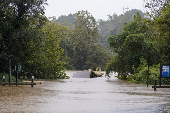
North Carolina may have seen the greatest flooding impacts from Helene; the city of Asheville in particular saw catastrophic damage from flood waters starting during the day Friday, but parts of a large swath of the western part of the state experienced major flooding. Communities along the Blue Ridge mountains saw some of the highest rainfall totals from Helene: Hendersonville clocked in at 22 inches, Spruce Pine at 24 inches, and in Busick, 31 inches. The city of Asheville itself received 14 inches, inundating its historic Biltmore Village. Buncombe County, home to Asheville, remains largely without power, and cellular service is limited at best. President Biden issued a major disaster declaration for Alexander, Alleghany, Ashe, Avery, Buncombe, Burke, Caldwell, Catawba, Clay, Cleveland, Gaston, Haywood, Henderson, Jackson, Lincoln, Macon, Madison, McDowell, Mitchell, Polk, Rutherford, Transylvania, Watauga, Wilkes, and Yancey Counties.

Flooding in Biltmore Village in Asheville, NC (Jacob Biba / Asheville Citizen Times)
In South Carolina, 24 deaths have been reported so far, approaching the number (26) killed by Hurricane Hugo, the state’s deadliest storm in modern history up to now. Most of these reports from Helene are due to falling trees. Parts of downtown Greenville, SC were flooded on Friday, and the nearby Reedy River overtopped its banks. Significant flooding and tree-related damage was also reported in parts of nearby Cherrydale, Honea Path, and Williamston.
Updated ALERT Plans for Helene
The Verisk ALERT team does not plan to release additional similar stochastic events for the wind and surge aspects of Helene at this time. As a reminder, the similar stochastic events provided through ALERT for tropical cyclones are selected based on wind and storm surge related storm parameters, and do not endeavor to reflect any potential inland flooding.
We expect that private insurance industry losses will exceed the losses indicated by Friday’s similar stochastic events, largely due to the apparently significant inland flooding component of Helene not captured therein. Given inland flooding appears to be a significant driver of the eventual insured loss tally for Helene, this sub-peril will be included in our custom remodeling of Helene, where we will also aim to address any other wind and storm surge aspects of the storm not captured by the similar stochastic events.
The Verisk ALERT Teams have been studying and modeling wind and storm surge impacts from Helen since Friday, and examination of the inland flood aspect of the storm is also underway. As of now, our plans for Helene are as follows:
- We plan to release a set of custom scenarios for Helene’s wind and storm surge impacts on Wednesday, October 2nd. This will include Touchstone and Touchstone Re event sets, loss based similar stochastic events, and median modeled wind and storm surge shapefiles. Given the significant proportion of insured loss likely to stem from inland flooding, we will not provide an official industry loss estimate with this posting.
- Once modeling of Helene’s precipitation induced flooding is complete, we will release updated event sets for Touchstone and Touchstone Re, updated loss-based similar stochastic events, and an insured industry loss estimate covering all three modeled perils, with timing for release still to be determined.
If there are changes to this plan, we will communicate them to all ALERT subscribers by email. Please contact your Verisk representative with any questions about Hurricane Helene.