Hurricane Milton
Status: Active
Custom Events | Summary
Posting Date: October 16, 2024, 6:00:00 AM
Verisk estimates that insured industry losses to onshore property for Hurricane Milton will fall between USD 30 billion and USD 50 billion. This estimate includes losses due to wind, privately insured estimates of storm surge, and privately insured precipitation induced flood losses resulting from Milton’s landfall in Florida. The vast majority of the insured loss is attributable to wind.
ALERT™ subscribers can now download Touchstone® and Touchstone Re™ event sets, loss-based similar stochastic events (SSEs), and hazard shapefiles of the median loss event for the wind and storm surge impacts from Hurricane Milton from the Downloads tab for this posting on the ALERT Website. Please see the commentary in the download for the loss-based similar stochastic events for guidance on how to best utilize these. The information provided herein is strictly confidential and is solely for the use of Verisk clients; disclosure to others is prohibited unless noted in your Verisk software license.
Modeling Information and Assumptions
The modeled scenarios in the custom event set for Hurricane Milton released today only include the wind and storm surge perils. While the overall industry loss estimate reflects precipitation induced flooding, this sub-peril is not included in the custom event sets released today.
Included in the industry insured loss estimate are losses to onshore residential, commercial, and industrial properties and automobiles for their building, contents, and time element coverage, as well as the impact of demand surge.
The modeled scenarios released today do not include:
- Losses from precipitation-induced flooding
- Losses paid out by the National Flood Insurance Program
- Losses exacerbated by litigation, fraudulent assignment of benefits, or social inflation
- Storm surge leakage losses paid on wind only policies due to government intervention
- Losses to inland marine, ocean-going marine cargo and hull, and pleasure boats
- Losses to uninsured properties
- Losses to infrastructure
- Losses from extra-contractual obligations
- Losses from hazardous waste cleanup, vandalism, or civil commotion, whether directly or indirectly caused by the event
- Losses resulting from the compromise of existing defenses (e.g., natural and man-made levees)
- Loss adjustment expenses
- Other non-modeled losses, including those resulting from tornadoes spawned by the storm
- Losses for U.S. offshore assets and non-U.S. property
Meteorological History of Milton
On the morning of October 5th, the National Hurricane Center (NHC) designated an area of low pressure in the extreme western Gulf of Mexico with increasingly defined circulation as Tropical Depression Fourteen. Scatterometer data collected around midday revealed that the system contained maximum sustained winds of 40 mph, thus necessitating an upgrade to Tropical Storm Milton.
As it continued to develop on the 5th into the early 6th, Milton lacked much in the way of forward speed, meandering generally northeastward at 3 to 5 mph. Despite the slow forward speed, Milton steadily increased in strength and by the afternoon of the 6th Milton had officially become a hurricane. Milton continued to steadily strengthen through the overnight hours on the 6th into the 7th, becoming a Category 2 hurricane, while moving generally eastward at a slightly faster pace.
This strengthening overnight and into the 7th marked the beginning of a nearly unprecedented episode of rapid intensification for Milton that saw the hurricane become a major hurricane around daybreak and reach Category 5 intensity around midday. Milton would continue strengthening during the second half of the day, reaching its peak intensity that evening with maximum sustained winds of 180 mph and a minimum central pressure of 897 mb as recorded by a Hurricane Hunters mission, making it the fifth lowest pressure of any Atlantic hurricane ever recorded. Milton’s central pressure dropped an astounding 84 mb in 24 hours (the third fastest Atlantic basin rapid intensification on record, behind Felix and Wilma) and in less than 24 hours the system had gone from a fledgling Category 1 hurricane to a powerful Category 5 storm.
Milton continued moving generally eastward on the 7th, with its center moving just north of the Yucatan Peninsula by later in the day into the overnight. After reaching peak intensity during the evening hours, Milton’s minimum central pressure rose, and its maximum sustained winds decreased overnight on the 7th into the 8th likely in large part due to an eyewall replacement cycle. This eyewall replacement cycle temporarily weakened Milton to a Category 4 hurricane but once completed the hurricane was now a larger storm and resumed its strengthening again on the 8th, becoming a Category 5 hurricane again late in the afternoon. Milton also began turning to move in a more northeasterly direction on the 8th, bringing the hurricane away from the Yucatan Peninsula and into the eastern Gulf of Mexico. Overnight on the 8th into the 9th, Milton generally maintained a steady intensity as a Category 5 hurricane as it moved closer to Florida.
On the 9th, conditions began to deteriorate across the southern Florida Peninsula as Milton’s outer bands began to reach shore, led by a robust tornado threat owing to the highly sheared environment over Florida produced dozens of reports across the southern part of the state during the day. Several of these tornadoes were quite large and caused structural and roof damage to buildings in populated areas like Fort Myers on the Gulf Coast and Vero Beach on the Atlantic Coast. In Palm Beach County, a wind gust of 92 mph was observed associated with a confirmed tornado passing close by.
Meanwhile, the same increasing wind shear that aided in the tornado threat was acting to steadily decrease Milton’s maximum intensity through the day, but also acted to expand its wind field, especially on the storm’s northwest side. As a result, by late afternoon tropical storm conditions were impacting much of the Florida Peninsula and as far west as Mexico Beach. Around this time, Milton’s heaviest rainfall bands were slamming into Florida’s central west coast and producing rainfall rates of 3-5 inches per hour that for some locations persisted for several hours. This core of rainfall gradually made its way inland, reaching Orlando shortly before midnight. Preliminary rainfall totals show just over 18 inches fell in Saint Petersburg and 11 inches at Tampa International Airport, leading to flash flooding and compounding the effects of storm surge along the coast. Significant flooding was observed at points along the coast and well inland.
Milton’s wobbling track ultimately steered the system south of Tampa, making landfall in Siesta Key and South Sarasota around 8:30pm as a Category 3 hurricane per the NHC. Despite the storm’s major hurricane status, the highest measured maximum sustained wind over land was 78 mph, or low-end Category 1 strength, in Venice. A few locations reported gusts of over 100 mph; including Tampa Skyway Fishing Pier (103 mph) and Sarasota-Bradenton International Airport (102 mph), with the high-water mark of 105 mph coming from an offshore platform in the middle of Egmont Channel at the mouth of Tampa Bay. It should be noted that there were likely higher sustained winds and wind gusts over land in some locations, especially near Milton’s landfall location, but their either was no instrumentation to measure these winds, or the instrumentation had failed because of power outages. The winds resulted in major structural damage near Tampa and St. Petersburg. In downtown Tampa, the roof was ripped off Tropicana Field and a crane was blown over into the Tampa Bay Times office building. As expected with a more southerly track, Tampa was spared from the worst-case storm surge scenario; rather than water being funneled into the Bay, Milton actually drained the Bay for a time. Areas south of the landfall point were not so fortunate and experienced significant to catastrophic surge from Milton. For example, the storm surge exceeded 10 feet in Sarasota and 5 feet in Fort Myers.
Milton continued to produce hurricane conditions for an isolated region near the storm’s core and widespread tropical storm conditions as it tracked east-northeast across the Florida Peninsula overnight. By 5am, Milton was moving off the Florida east coast, still a low-end hurricane with estimated maximum sustained winds of 85 mph; around this time an observation of 83 mph sustained wind and a 92-mph gust was reported by a Weatherstem station in Marineland, at the Flagler / St. John’s county line along the Atlantic coast. Well over 3 million Florida residences were left without power in Milton’s wake.
By morning on the 10th, Milton’s center had moved offshore of the Atlantic, still a Category 1 hurricane and still producing storm surge and tropical storm conditions in eastern Florida and portions of the Georgia coastline. By early afternoon, Milton completed its post-tropical transition as it continued to move out into the open Atlantic.
Validation of the Verisk’s Modeling of Milton
Wind and Storm Surge Damage
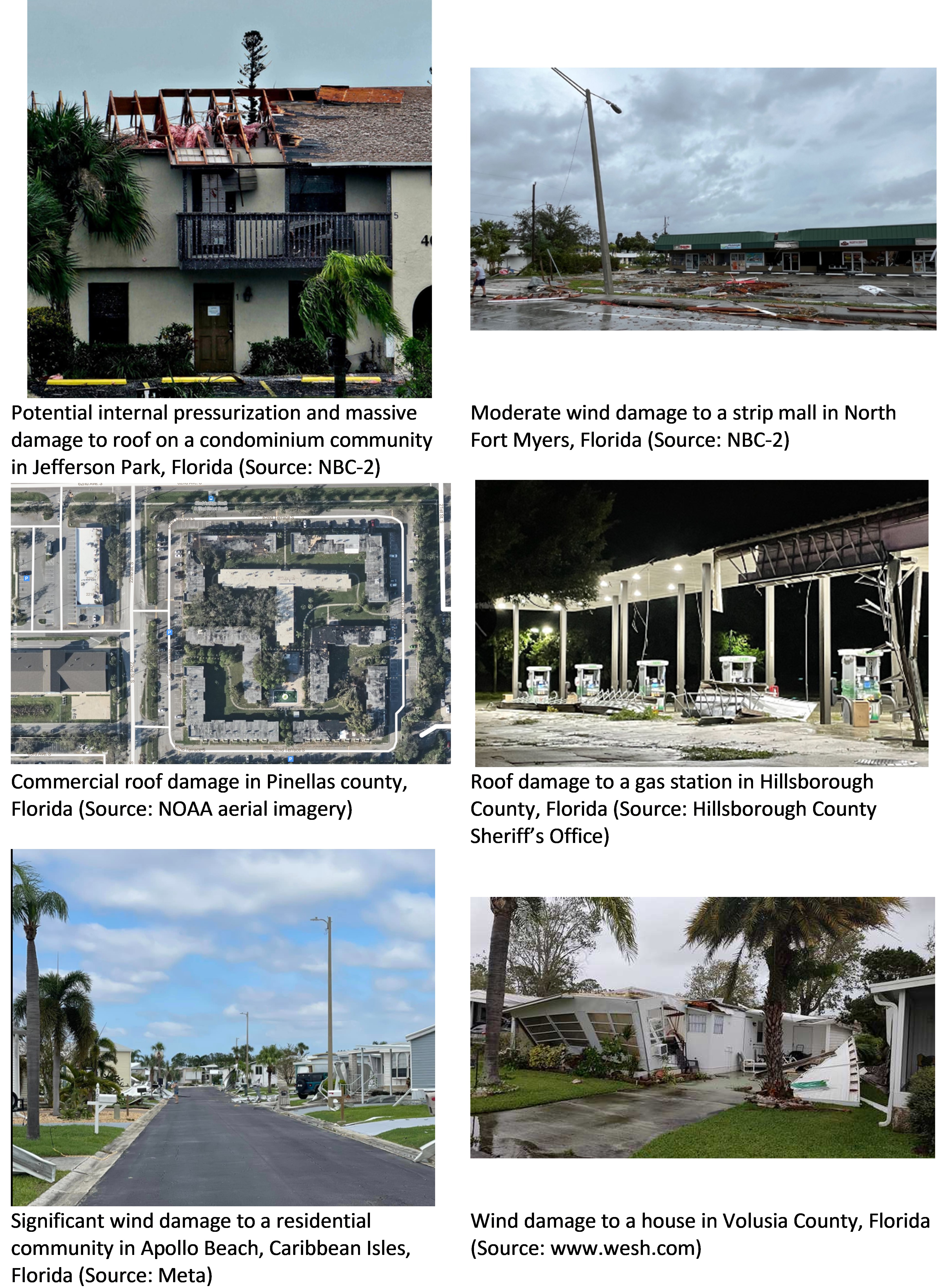
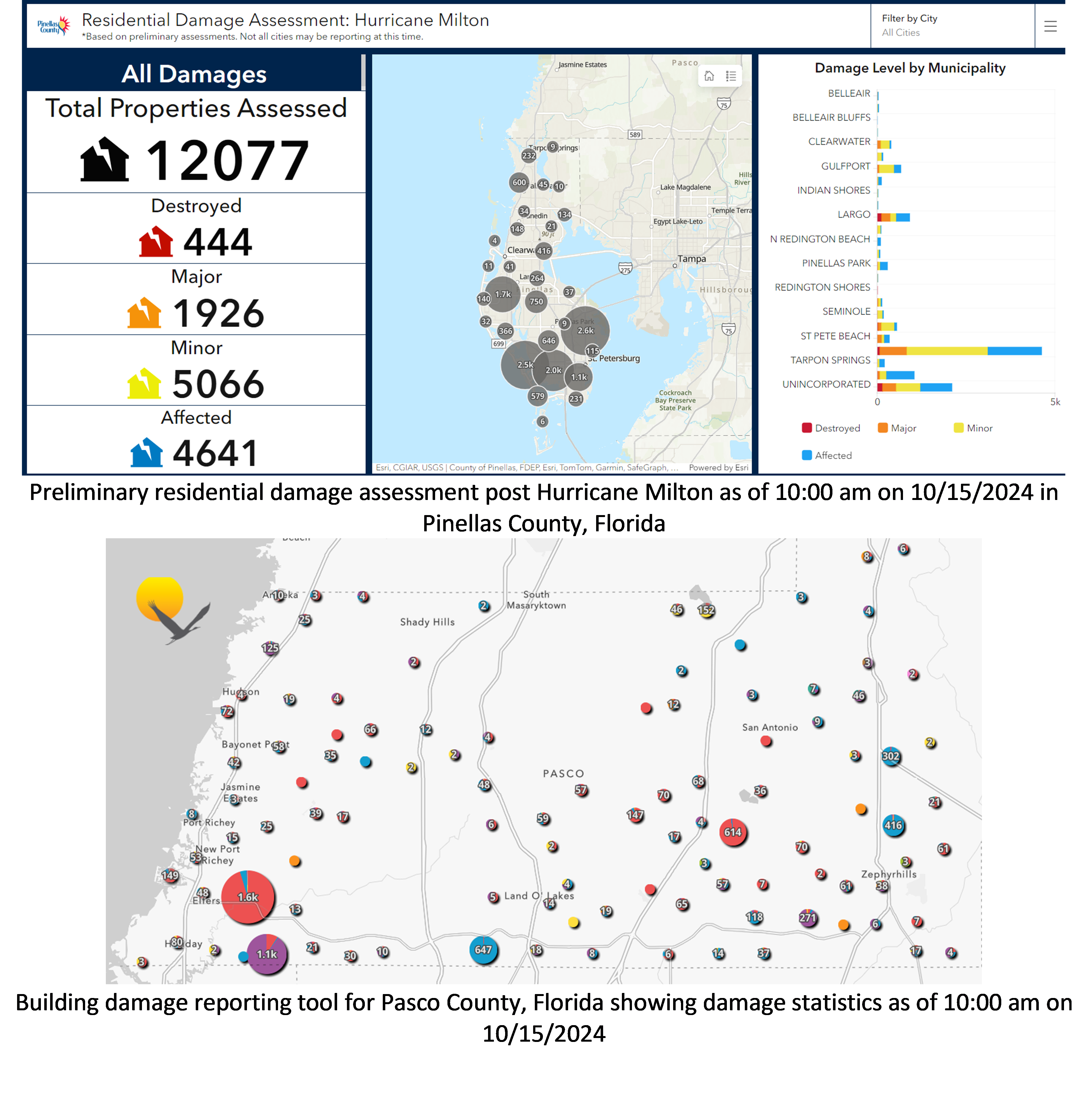
Wind damage to varying degrees was observed all along Milton’s footprint: along the coast as well as areas inland. Significant wind damage to residential and commercial properties was observed in Sarasota County where Milton made landfall as shown in Figure 1. Wind damage was observed as far south as Lee County and as far north as Hernando counties along the coast. Inland counties also experienced wind damage to the envelope elements of the buildings and also downed trees on buildings. Representative images are shown in Figure 2. Certain counties also had dashboards to report damage across the county and these provide excellent resources to validate the nature and spatial extent of damage in addition to the extent of damaging winds from the Verisk scenario set. Figure 3 shows examples of the same in Pinellas and Pasco counties.

Figure 1: Significant wind damage to residential and commercial properties in Sarasota County where Hurricane Milton made landfall

Figure 2: Evidence of wind damage across Milton’s footprint along Gulf and Atlantic coast counties in Florida

Figure 3: County wide damage statistics dashboards showing nature and spatial extent of damage to properties
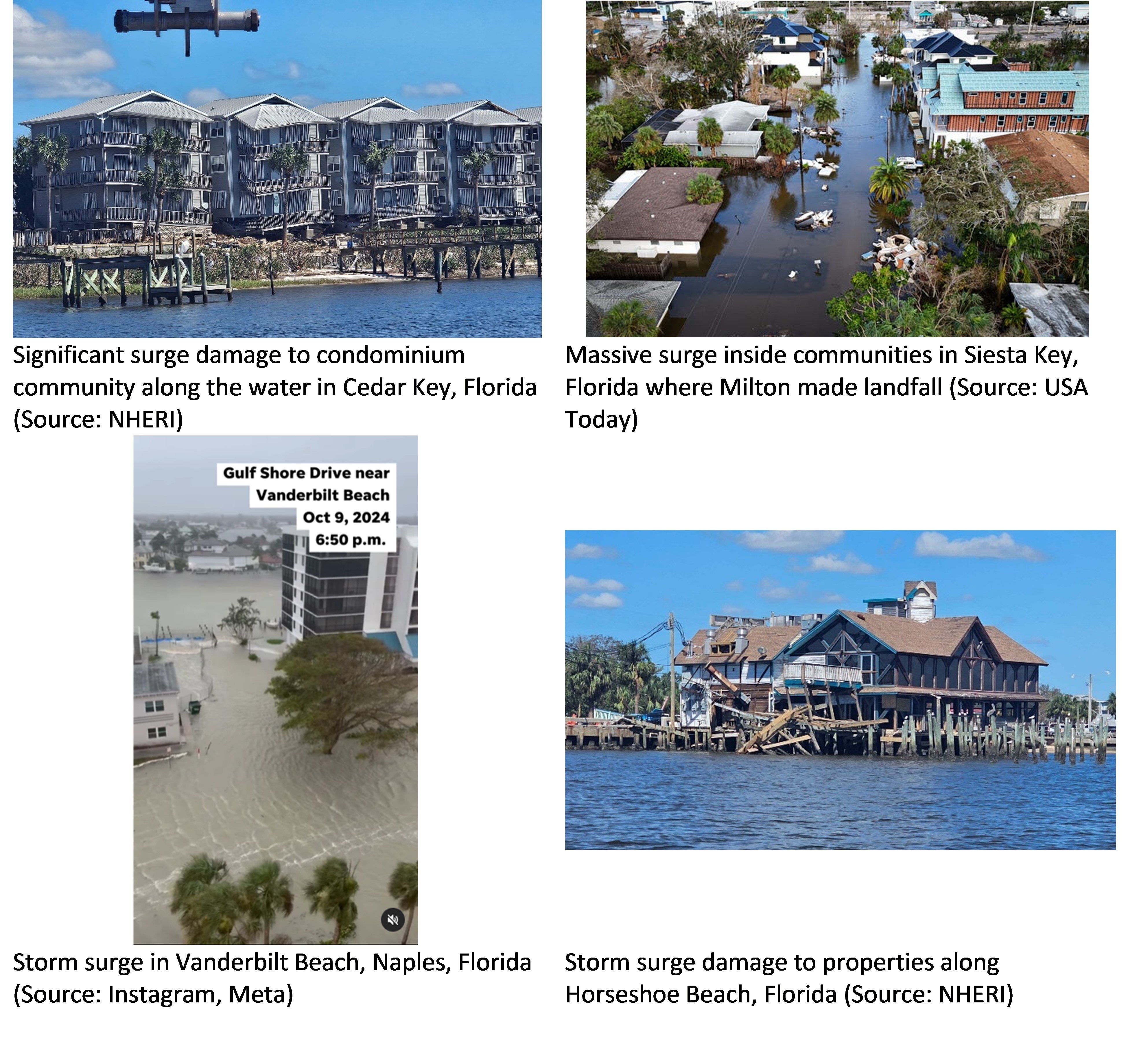
While wind damage was observed far and wide, significant storm surge damage was also observed particularly to the southern Gulf coast counties to the right side of Milton’s track. Surge damage was observed as far south as Naples County. Figure 4 shows representative surge damage to properties from some of these areas.

Some neighborhoods on the northern part of Milton’s track saw local flooding due to precipitation induced flooding. This was seen predominantly in Hillsborough, Pinellas, Pasco and Hernando counties. Losses from this peril are not expected to significantly contribute to the overall insured loss tally from Hurricane Milton. In addition to this, several counties in the southern part of Milton’s track saw severe localized damage due to tornadoes. These were seen in Lee County on the Gulf Coast and Nassau, St. Lucie, Highlands, Brevard, Martin, Palm Beach counties on the Atlantic coast, to mention a few.
Putting Damage in Perspective from the Context of Building Codes
Florida has a long history when it comes to the evolution and adoption of building codes. Right from its very first adoption of the statewide building code in 2002, it has been a pioneer nationally in wind design specifications. The figure below shows the timeline of Florida Building Code (FBC) adoption.

Figure 5: History of Florida Building Code adoption cycle (Source: Verisk)
The building code stipulated wind speeds that guide the design of residential and commercial buildings in southwest Florida are in excess of 150 mph (3-sec gust values) across these code versions. Further, vast swaths of areas where Milton made landfall fall under the windborne debris regions which require openings to be protected. Wind speeds that were observed in areas impacted by Milton, at landfall and further inland, fall well below the design levels. However, more than 50% of the risks in counties along the Gulf coast are built before the first version of the FBC came into effect. While a significant portion of the inventory is over 20 years old, the age of the roof can also provide a valuable insight into expected building performance since roofs are the first lines of defense when it comes to wind. We see that a significant portion of these risks have been reroofed within the last decade. Additionally, at least 65% or more of these roofs have been newly built or reroofed in the FBC era.
When it comes to appurtenant structures such as screened enclosures, these are designed to much lower levels in comparison to the main building. Typically, for these design levels are in the order of 140 mph (3-sec gust values). The relatively flimsy nature of materials that go into their construction combined with aging and deterioration impacts make these more vulnerable to damage. Further, the wind speeds that Milton brought to some of the impacted areas right around landfall could be around these design levels and therefore significant damage should be expected to these structures.
Manufactured homes on the other hand are designed and constructed using the federal Housing and Urban Development (HUD) standards. These standards have not changed since 1995 and specify design levels of 110 mph (fastest mile) without any additional safety factors. This is equivalent to approximately 130 mph on 3-sec gust basis. Depending on the age and level of deterioration of the manufactured home building stock and more importantly their respective tie downs (or lack of), the wind speeds that Milton brought to some of the impacted areas right around landfall could lead to widespread damage to these even though it was below their design levels.
Other Considerations
Interactions with Damage from Hurricane Helene
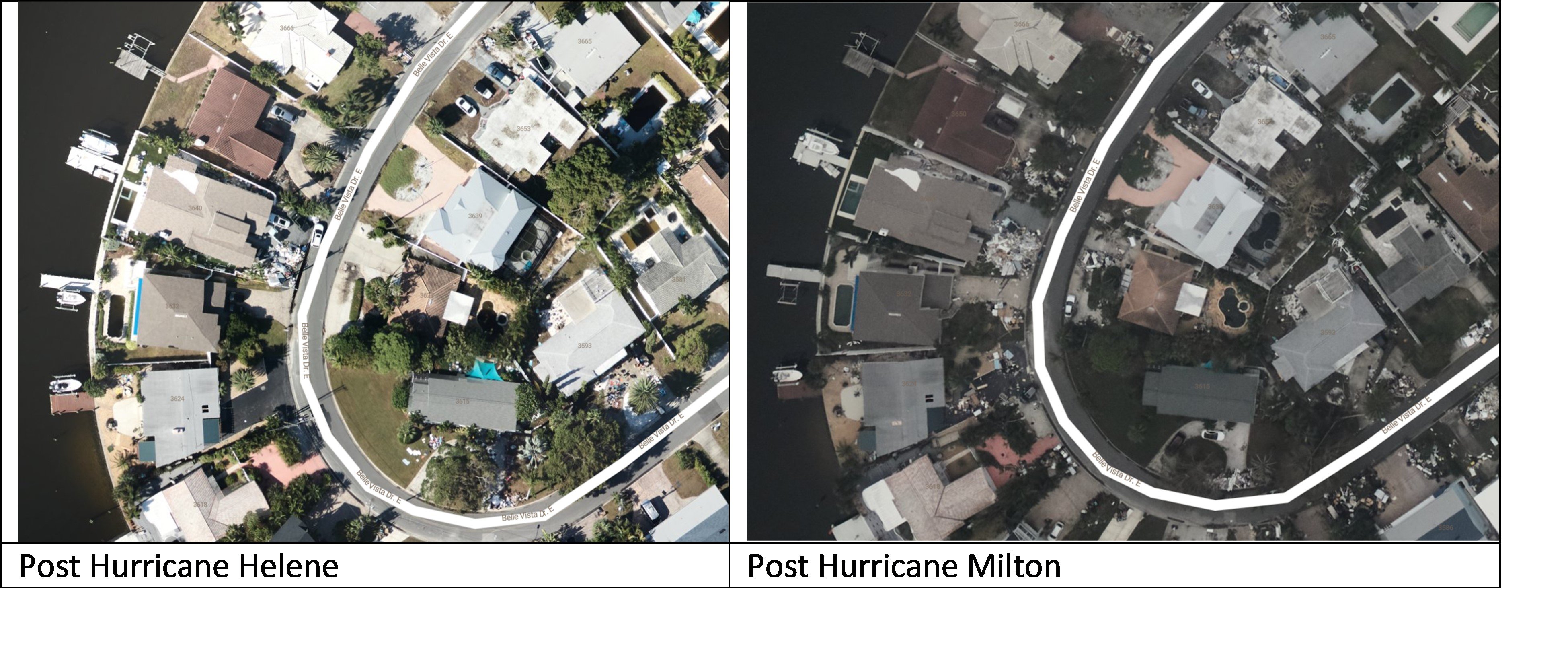
Helene and Milton impacting Florida back-to-back over such a short time period could have some impacts on loss development and settlement for both storms. Only Ivan and Jeanne in 2004 hit Florida as major hurricanes over a shorter period than Helene and Milton going back to 1851. One challenge that is likely to arise is over the attribution of loss to each event. Areas around Tampa Bay, south to Siesta Key, and along the coast due south toward Fort Myers were all impacted by both storms, and the area south of Tampa saw significant storm surge from both events. In addition to claims settlement challenges, the back-to-back coastal flooding events could lead to aggregate flood limits being reached in some cases. One aspect that is unique when it comes to Hurricane Milton is the debris pile up and non-removal of the same following Hurricane Helene which impacted some of the same counties along the Gulf coast a few weeks ago. There are numerous images and reports of massive debris left outside properties, on the streets which could have further exacerbated damage from Hurricane Milton by acting as projectile sources, despite efforts to clean up before Milton’s arrival. Figure 6 shows post Helene and post Milton aerial imagery from the same community along Long Key, Pinellas County where this can be seen.

Figure 6: Compounding storm consequences: Hurricane Helene’s storm surge created debris piles that were yet to be removed prior to Hurricane Milton’s arrival in Long Key, Pinellas County, Florida (Source: NOAA aerial imagery)
Another factor in the interaction between these events is the potential for demand surge to increase. Verisk research on demand surge following the 2004 Atlantic hurricane season, when four storms impacted Florida within six weeks, shows that the impacts of demand surge on these losses from events in close spatial and temporal proximity is closer to what would be expected for an industry loss event of the total loss across events versus what would be expected considering the events individually.
Finally, it should be noted that while Milton is expected to have a significantly higher insured loss tally than Helene, the difference between the events insured losses is driven in large part by the lower take up rates on flooding in areas impacted by Helene, particularly inland areas impacted by precipitation-induced flooding. Verisk’s modeling of both storms indicates that the overall levels of damage between the two events are comparable but given much higher proportion of wind loss from Milton, a far higher percentage of the potentially insurable loss will be paid out by the insurance industry.
National Flood Insurance Program
The flood insurance take-up on residential risks in Florida is variable depending on the county. Recent data from the National Flood Insurance Program (as of 8/31/2024) shows that the risk count based take-up rates of policies-in-force varies from 48-50% in Pinellas, Charlotte and Lee Counties to as low as 5-15% in a majority of counties along the Gulf coast including Taylor, Citrus, Dixie, Hernando, Levy, Pasco, and Hillsborough counties.
Homeowners who choose to purchase flood insurance most commonly do so through the National Flood Insurance Program (NFIP), and Florida has the highest proportion of NFIP policies of any state – about 35%, according to Fitch Ratings. These policies typically cover up to $250,000 in damages and do not include additional living expense coverage, suggesting that even for some homeowners with flood insurance, there may be a gap between coverage and rebuilding costs.
Other Verisk Resources for Hurricane Milton
Verisk Respond Hurricane Data
Verisk’s Respond Hurricane solution uses a multi-input model to provide a comprehensive and accurate view of tropical cyclone winds. The solution couples a five-day forecast of wind with a post-event view to provide a full wind field understanding of the impacts that have already occurred alongside the potential impacts that have yet to occur from a tropical system. The Respond Hurricane solution updates every six hours for any named storm in the Atlantic Ocean basin. Wind information is expressed both in terms of one-minute sustained wind speeds as well as three-second wind gusts. In addition, wind speed durations of 39 mph or greater (tropical storm force), 50 mph or greater, and 74 mph or greater (hurricane force) are also conveyed to provide a more comprehensive understanding of the wind threat.
In the event of a landfalling U.S. hurricane, within 24 hours of downgrade of the system to a tropical depression or post-tropical system, the Verisk Respond Hurricane maximum wind gust data are corrected by assimilating actual wind observations from multiple sources into the wind field to bias and error correct the modeled estimate. Special consideration is taken in this process to ensure the wind observations being incorporated accurately reflect the conditions at the location at a 10-meter height. This final maximum wind gust field will not only more closely match the assimilated observations, but final wind field values will be more accurate in general across the entire wind field, although typical differences between the modeled estimates and the observation-corrected post-storm are 10% or less.
Please contact your Verisk representative for more information on Verisk Respond.
Additional ALERT Plans for Milton
The Verisk Flood team is continuing to refine their understanding of Milton’s precipitation-induced flood impacts. While no additional ALERTs are currently scheduled, an additional update may be made to explicitly include the precipitation-induced flood sub-peril in the custom event sets. We will provide an update in the coming days on any additional plans. Please contact your Verisk representative in the meantime for any questions regarding Hurricane Milton.
Custom Events | Downloads
Posting Date: October 16, 2024, 6:00:00 AM
The information provided herein is strictly confidential and is solely for the use of Verisk clients; disclosure to others is prohibited.
Simulated Event Sets
These event sets contain five custom modeled scenarios for Hurricane Milton's wind and storm surge, allowing for uncertainty in key model parameters such as radius of maximum winds and central pressure. All scenarios follow the official NHC track.
| Product | Description | Download |
|---|---|---|
| Touchstone Re | Selected set of simulated scenarios | |
| Touchstone | Selected set of simulated scenarios |
Loss Based Similar Stochastic Event IDs
These stochastic events were selected as best matches to the insured industry loss footprints generated by the custom modeled scenarios in the Simulated Event Set.
Additional Downloads
Please use the appropriate application to view these files.