Hurricane Debby
Status: Closed
| Type of posting | Posting date(EST): | Summary | Downloads |
|---|---|---|---|
| August 8 Update | 8/8/2024 1:00:00 PM |
|
|
| Landfall SSEs | 8/5/2024 10:00:00 AM |
|
|
August 8 Update | Summary
Posting Date: August 8, 2024, 1:00:00 PM
Debby made a second U.S. landfall on Thursday morning, near Bulls Bay, South Carolina as a Tropical Storm with estimated maximum 1-minute sustained winds of 50 mph. Debby will move across the Carolinas today, following the Appalachians up to the northeast U.S. through the upcoming weekend.
Debby initially came ashore just a few miles from last year’s Hurricane Idalia, though the Category 1 storm did not bring the same level impacts as Idalia from wind and storm surge. Cedar Key, Florida saw a peak inundation above ground level of about 4.6 feet from Debby’s surge, well below the 8-plus foot water levels observed following Idalia in the Big Bend area of Florida. The highest wind gusts observed were all in Florida: a gust of 76 mph was observed at Chiefland, a 73 mph gust at Dania Beach, and a 70 mph gust near Palmetto. In South Carolina, the peak observed wind gust was 63 mph at Folly Beach.
While the rainfall and resulting flooding has not quite reached the most dire scenarios predicted prior to the storm’s arrival, precipitation totals from Debby have been prodigious. Several sites across Florida have reported more than a foot of rain from Debby, led by Lake City reporting 19.67 inches for the storm in total. Several areas of Georgia and South Carolina have also seen more than a foot of rain over the past few days, with over 18 inches reported in Summerville, South Carolina. Additional wind and rainfall observations from Debby can be found here.

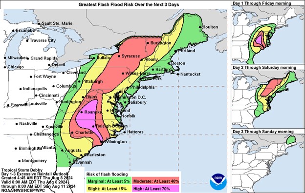
National Weather Service Excessive Rainfall Forecast for Debby as of August 8th (NWS)
Debby has also spawned at least 11 tornadoes since Monday, including EF-1 events in Edisto Beach and Moncks Corner in South Carolina. Thousands of flights have been cancelled or delayed over the past week across the east coast. According to poweroutage.us, approximately 140,000 customers are currently without power in the Carolinas, the majority in North Carolina. As Debby continues to the northeast, an additional 3 to 9 inches of rain is possible in eastern South Carolina and southeast North Carolina, as well as the threat for more tornadoes. Significant flooding could impact parts of Virginia as well, including the city of Roanoke, and locally significant impacts are possible across Debby’s track through this weekend.
At this time, the Verisk ALERT team does not have plans to release additional loss estimates for Hurricane Debby. However, given the event is still developing, we will continue to monitor through the weekend and provide another update no later than next Tuesday, August 13. Please contact your Verisk representative with any additional questions about this event.