Hurricane Francine
Status: Closed
| Type of posting | Posting date(EST): | Summary | Downloads |
|---|---|---|---|
| Landfall SSEs | 9/12/2024 11:00:00 AM |
|
|
| Pre-Landfall SSEs #2 | 9/11/2024 10:00:00 AM |
|
|
| Pre-Landfall SSEs #1 | 9/10/2024 10:00:00 AM |
|
|
Landfall SSEs | Summary
Posting Date: September 12, 2024, 11:00:00 AM
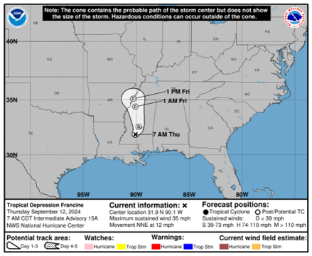
Francine made landfall Wednesday evening in Terrebonne Parish in Louisiana, packing estimated 1-minute sustained winds approaching 100 mph and a minimum central pressure around 972 mb, per the National Hurricane Center. Francine weakened rapidly after landfall and has since been downgraded to a Tropical Depression. More than 400,000 households were without power at the peak of the storm, and 14 million persons remain under flash flood watches today. Among the higher reported wind gusts were 105 mph on Eugene Island, 97 mph in Dulac, and 78 mph at New Orleans International Airport. Thus far, damage reports are centered around power lines and trees falling, as well as some storm surge flooding immediately along the coast and some roof damage. Some street flooding was also observed, including in the city of New Orleans.
ALERT™ subscribers can download similar stochastic event (SSE) IDs for Francine from the Downloads tab of this posting on the ALERT website. Compatible with Touchstone® and Touchstone Re™, the SSEs were selected based on the event’s projected key meteorological parameters at landfall, in particular storm track, minimum central pressure, estimated winds, forward speed, and landfall angle. They were selected primarily for impacts in Louisiana and can also be used to broadly capture storm impacts in Mississippi.

As Francine moves inland, the main threat will be from flash and urban flooding. According to the National Hurricane Center, Francine is expected to bring storm total rainfall of 3 to 6 inches across portions of Mississippi, eastern Arkansas, Tennessee, Alabama, Georgia, and the Florida Panhandle, with localized amounts up to 10 inches are possible within rain bands over portions of central and northern Alabama and over the Florida Panhandle.
The Verisk ALERT team is currently assessing the impacts from Francine and will provide guidance on next steps for this storm by Friday, September 13, EDT. In the meantime, please contact your Verisk representative with any questions about this event.
Landfall SSEs | Downloads
Posting Date: September 12, 2024, 11:00:00 AM
The information provided herein is strictly confidential and is solely for the use of Verisk clients; disclosure to others is prohibited.
Similar Stochastic Event IDs
Note: These lists give event IDs taken from our stochastic catalog that have similar characteristics as the current event.
Track shapefiles are not available for this posting.