Hurricane Milton
Status: Active
Pre-Landfall SSEs #1 | Summary
Posting Date: October 7, 2024, 10:00:00 AM
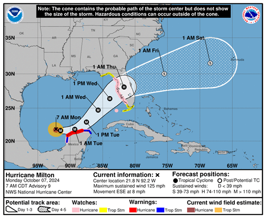
As of 8am EDT, Hurricane Milton was located 745 miles west-southwest of Tampa, Florida, with estimated 1-minute sustained winds of 125 mph and a minimum central pressure of 945 mb. Per the National Hurricane Center, Milton is moving toward the east-southeast near 8 mph. An eastward to east-southeastward motion is forecast through tonight, followed by a turn toward the east and northeast on Tuesday and Wednesday. On the forecast track, Milton is forecast to move near or just north of the Yucatan Peninsula today and Tuesday, then cross the eastern Gulf of Mexico and approach the west coast of the Florida Peninsula by Wednesday. Milton is currently forecast to be a major hurricane as it approaches the Florida coastline, though some weakening due to increasing wind shear is forecast just prior to expected landfall.
ALERT™ subscribers can download similar stochastic event (SSE) IDs for Milton from the Downloads tab of this posting on the ALERT website. Compatible with Touchstone® and Touchstone Re™, the SSEs were selected based on the event’s projected key meteorological parameters at landfall, in particular storm track, minimum central pressure, estimated winds, forward speed, and landfall angle. They were selected for impacts in Florida.

An updated set of similar stochastic events for Hurricane Milton will be posted around 10:00 am EDT each day through landfall, reflecting the latest forecast scenarios at that time. Please contact your Verisk representative with any additional questions about this event.
Pre-Landfall SSEs #1 | Downloads
Posting Date: October 7, 2024, 10:00:00 AM
The information provided herein is strictly confidential and is solely for the use of Verisk clients; disclosure to others is prohibited.
Similar Stochastic Event IDs
Note: These lists give event IDs taken from our stochastic catalog that have similar characteristics as the current event.