Hurricane Milton
Status: Active
Pre-Landfall SSEs #3 | Summary
Posting Date: October 9, 2024, 10:00:00 AM
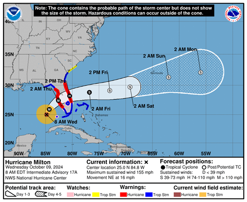
As of 8:00 am EDT, Hurricane Milton was located 250 miles southwest of Tampa, Florida, with estimated 1-minute sustained winds of 155 mph and a minimum central pressure of 915 mb, per the National Hurricane Center. Milton is moving east-northeast at 12 mph. A northeastward motion is expected through tonight. A turn toward the east-northeast and east is expected on Thursday and Friday. On the forecast track, the center of Milton will move across the eastern Gulf of Mexico today, make landfall along the west-central coast of Florida late tonight or early Thursday morning, and move off the east coast of Florida over the western Atlantic Ocean Thursday afternoon.
ALERT™ subscribers can download similar stochastic event (SSE) IDs for Milton from the Downloads tab of this posting on the ALERT website. Compatible with Touchstone® and Touchstone Re™, the SSEs were selected based on the event’s projected key meteorological parameters at landfall, in particular storm track, minimum central pressure, estimated winds, forward speed, and landfall angle. They were selected for impacts in Florida.

An updated set of similar stochastic events for Hurricane Milton will be posted around 10:00 am EDT on Thursday, reflecting the latest information at that time. An update on impacts will follow on Friday, and an industry loss estimate and additional custom modeling resources will be available by early next week. Please contact your Verisk representative with any additional questions about this event.
Pre-Landfall SSEs #3 | Downloads
Posting Date: October 9, 2024, 10:00:00 AM
The information provided herein is strictly confidential and is solely for the use of Verisk clients; disclosure to others is prohibited.
Similar Stochastic Event IDs
Note: These lists give event IDs taken from our stochastic catalog that have similar characteristics as the current event.