
Station Fire
Status: Closed
| Type of posting | Posting date(EST): | Summary | Downloads |
|---|---|---|---|
| Update 3 | 9/21/2009 1:00:00 PM |
|
|
| Update 2 | 9/2/2009 10:51:00 AM |
|
|
| Update 1 | 9/1/2009 10:00:00 AM |
|
|
| First Posting | 8/31/2009 2:00:00 PM |
|
Update 3 | Summary
Posting Date: September 21, 2009, 1:00:00 PM
The Station Fire, which at its peak threatened 12,000 homes in the foothill communities northeast of Los Angeles, is currently 94% contained after more than three weeks of persistent firefighting efforts. The fire began on August 26th near a USFS Ranger Station in the Angeles National Forest and has consumed a total of 160,557 acres (over 250 square miles), making it the 10th largest blaze in California since 1933. (Click here to download a Google Earth .kmz file showing the fire’s progression. Click the play button at the top right of the screen to start the animation, and adjust the animation speed by clicking the clock icon). The blaze, which killed two firefighters and destroyed 89 residences, is believed to have been deliberately set, and officials continue to search for those responsible.
The steep and rugged terrain, inaccessible by ground vehicles in many places, made containment efforts very difficult in the early days of the fire. In addition, there was no precipitation during the fire; fuel moisture readings were as low 4–5% on some days, and only occasionally greater than 10%. The very rapid spread of the fire, in the absence of high winds, can be attributed to the extremely dry fuels. Fortunately, temperatures were quite moderate. In the mountains of the Angeles Crest where the Station Fire burned, temperatures typically ranged from low 60s to mid-to-high 80s. It is important to note, however, that in the valleys below, there were numerous reports of temperatures over 100. This would have greatly complicated firefighting efforts had the fire penetrated those urban areas.
The principal mitigating circumstance that prevented the Station Fire from destroying more homes was the moderate winds. Indeed, hourly reported sustained wind speeds near the fire only rarely exceeded 10 mph. There were a number of periods when wind gusts exceeded 20 mph and, occasionally, even 30 mph. Although these occurrences set back firefighting efforts and delayed the ultimate containment and control of the fire, they were too infrequent to allow it to run completely out of control.
Had the infamous Santa Ana winds been present, the situation could have been far different. Typically beginning in autumn, these hot and dry winds originate in the desert and sweep through southern California toward the coastline. In October 2003, several southern California wildfires driven by Santa Ana winds, including the Cedar and Old Fires, burned over 700,000 acres and destroyed over 3000 homes. In 1991 the Oakland Hills Fire, the costliest in U.S. history with insured losses between $3.0–3.5 billion in today’s dollars, was likewise fanned by Santa Ana-type winds.
Like the Station Fire, the Oakland Hills Fire started at the wildland-urban interface adjacent to very densely populated areas with high exposure value. As a point of comparison, however, the Oakland Hills Fire consumed just 1600 acres (2.5 square miles). At the peak of the Station Fire, its active southwestern flank—which would have advanced rapidly had the northeasterly Santa Ana winds been present—stretched about 10 miles. The figure below shows the southwestern perimeter of the Station Fire in red, along with the commercial and residential exposure value of the adjacent communities, which totals $17 billion according to AIR’s 2008 industry exposure database. As shown in the map, the perimeter of the fire stopped just short of these suburban neighborhoods. Had Santa Ana winds pushed the fire into these areas, losses likely would have been catastrophic—comparable at least to the Oakland Hills Fire.
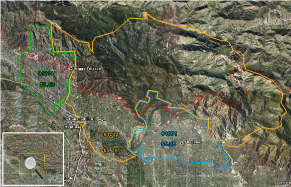
This map shows the total residential and commercial property value in three communities along the southeastern perimeter of the Station Fire, which is marked in red. (Source: Geomac/AIR)