2017 California Wildfires
Status: Closed
First Posting | Summary
Posting Date: October 12, 2017, 9:00:00 AM
A shapefile for use in Touchstone® containing perimeters of nine of California’s currently active wildfires is now available on the Downloads tab of this posting (login required). Also posted is a list of ZIP Codes within those perimeters.Beginning late last week, multiple wildfires exacerbated by hot, dry, and windy conditions have spread across eight counties of California, consuming more than 170,000 acres and destroying more than 3,500 structures. According to CalFire, as of 1:00 p.m. October 12, 2017, 22 fires are currently active. Two of these blazes have reportedly been contained. The California governor has declared an emergency in 9 counties, including Napa, Sonoma and Yuba. President Trump has authorized emergency federal aid for the state. The National Guard has also been mobilized. The causes of the fires remain under investigation. Officials have estimated that 50,000 people have evacuated from their homes, as many as 25,000 of them in Sonoma County alone. Evacuation orders have widened today, with residents of Calistoga and Geyserville now under mandatory evacuation orders. Meanwhile, the death toll has risen to 23 and that number may rise.
The steep and rugged terrain, in many places inaccessible by ground vehicles, has made containment efforts difficult. In addition, there has been no precipitation and none is expected for at least several days; despite a wet winter, California continues to be impacted by five years of drought conditions, and fuel moisture readings are as low 4–5% on some days, and only occasionally greater than 10%. The Northern California Diablo winds—usually spawned as high pressure builds over the West and air flows toward areas of lower pressure along the coast—fanned flames on the ridge tops with gusts as high as 70 mph.

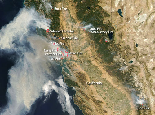
Actively burning wildfires in California as seen from space. (Credit: Jeff Schmaltz LANCE/EOSDIS MODIS Rapid Response Team, GSFC)
Current Conditions and Wildfire Risk
The winds again picked up overnight, hampering containment efforts. As of Thursday, October 12, the three most dangerous wildfires are still active in northern California. The Tubbs Fire, just 10% contained, has spread across 30,000 acres, forcing the evacuation of 20,000 people. The Atlas Fire, which has burned 26,000 acres in Napa and Solano counties, is currently only 3% percent contained. The Redwood/Potter fires, which ravaged 21,000 acres in Mendocino County, is 5% contained.
Thousands of fire personnel are battling the fires, including crews from outside California. Air tankers dropped 266,000 gallons of retardant from the skies on Monday. Fueled by herbaceous fuels, either curing or dead and other drought-dry brush on steep, rugged hills with limited access, the wildfire has challenged fire crews attempting to build fire lines and control the perimeter. State officials said that firefighters planned to clear lines between the Atlas Fire and the city of Napa, and between the Tubbs Fire and the city of Santa Rosa — the largest in Sonoma County. Those barriers would protect the areas from the south in anticipation that winds will shift back to the north in the coming days.
The National Weather Service, citing increased winds and low humidity has issued a “red flag warning” for areas in the North Bay area, which includes Sonoma and Napa counties. A red flag warning means conditions exist to promote “explosive fire growth potential.”
Reported Damage and Insurance Implications
With the fires still far from under control, it is too soon to have an accurate picture of the destruction, but it is clear that there has been a significant loss of property.
Thousands of people have fled the area, schools have been closed, flights cancelled, and mandatory evacuations have been ordered for several areas including Butte, Yuba, Nevada, Calaveras, Lake, Sonoma, Solano and Mendocino counties. About 100,000 PG&E customers in the Napa and Sonoma counties were without power on Tuesday.
The most extensive loss to property appears to have occurred in Santa Rosa. Two hotels and a motel—the Fountaingrove Inn, the Hilton Sonoma Wine Country Hotel and the Best Value Inn and Suites—were engulfed by the Tubbs Fire, which also destroyed most of the single-family homes in the neighborhood called Coffey Park and dozens of mobile homes in Journey’s End Mobile Home Park. Three miles north of Santa Rosa, the fire ripped through Arby’s and Applebee’s restaurants, Willi’s Wine Bar, the Cricklewood steakhouse, and a building that housed a mini-mart and a McDonald’s restaurant.

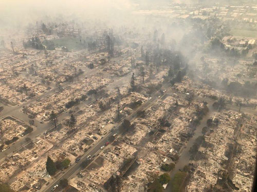
Devastated Coffey Park neighborhood of Santa Rosa, California. Courtesy of California Highway Patrol, Golden Gate Division.
AIR estimates that the average rebuild cost of single-family homes within the perimeter of the Tubbs Fire is about USD 450k, but there is considerable variability within that. Buildings in the area are typically constructed of stucco walls and chimney finishes, have shed (flat) roofs covered with low-pitched clay tile and terra cotta or cast-concrete ornaments. The homes generally have little cleared area separating them from the surrounding vegetation, which consists of an equal mix of chaparral, brush, and conifers.
Several wineries have also been impacted. The Paradise Ridge Winery in Santa Rosa burned to the ground. Others included Nicholson Ranch in Sonoma, Signorello Estates in Napa, Oster Wine Cellars, and Frey Vineyards in Mendocino County’s Redwood Valley. While there will likely be significant damage to plant materials and trellises, the vineyards will also experience other losses related to equipment, irrigation, and waste water treatment systems. It can take up to five years to restore soils to the point where scorched vines can again produce grapes suitable for winemaking. California is the fourth largest wine-producing region in the world with more than 1,200 wineries.
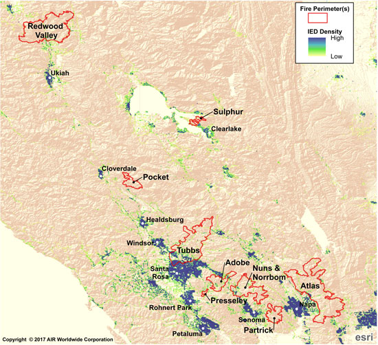
The map below shows the perimeters of the nine active fires for which AIR is providing shapefiles for use in Touchstone overlaid on AIR’s industry insurable exposure.

Perimeters of nine active wilfires in Northern California ovelaid on density map of AIR's industry insurable exposure. (Source: GeoMAC and AIR)
Forecast intensity
Although winds are expected to ease somewhat over the next few days and temperatures to cool, winds may shift again later in the week—and there is little prospect for any significant rainfall. With nearly two dozen fires still out of control, the situation in California remains extremely dynamic.
The AIR Wildfire team continues to monitor the situation in California and will provide more information as warranted by events.
A shapefile containing perimeters of nine of California’s currently active wildfires is available on the Downloads tab of this posting (login required). Also posted is a list of ZIP Codes within those perimeters. Posted fire perimeters from GeoMAC (timestamp: 10/12/2017 7:10 AM) are as follows:
1. Redwood Valley(Mendocino-Lake Complex)
2. Sulfur/Sulphur (Mendocino-Lake Complex)
3. Pocket(Central LNU Complex)
4. Tubbs (Central LNU Complex)
5. Pressley Fire (Southern LNU Complex)
6. Adobe Fire (Southern LNU Complex)
7. Nuns -Norrbom Fire (Southern LNU Complex)
8. Partrick Fire (Southern LNU Complex)
9. Atlas Fire (Southern LNU Complex)