2017 California Wildfires
Status: Closed
Update 3 | Summary
Posting Date: November 9, 2017, 8:00:00 AM
Last week, AIR Worldwide dispatched a team to survey the damage caused by the wildfires that began in Sonoma and neighboring counties of California on October 8. They confirmed what by then most of us already suspected: this siege of six named fires (Atlas, Nuns, Pocket, Redwood, Sulphur, and Tubbs) was unprecedented in terms of both the physical damage it inflicted on property and the financial severity it represents for the insurance industry.
We continue to analyze the survey findings and additional information about policy terms and conditions (limits, or lack thereof, on ALE coverage, for example), potential coverage leakage, and the sources of uncertainty around what may ultimately be paid out in claims for impacts outside the fire perimeters.
The information below should therefore be viewed as an interim update. AIR will release an updated loss estimate for the siege by the end of next week when the analysis is complete. Ultimately, however, it is clear that AIR’s initial loss estimates for these fires are significantly lower than what we now expect the industry will pay out.
Historical California Wildfires and Their Damage Ratios
To understand just how far removed from previous experience this siege was, one can first focus on what occurred in the Tubbs Fire and contrast that with other historical wildfires. A metric that AIR Worldwide uses to capture the severity of a wildfire is the “damage ratio,” or ratio of total insured losses to total insured value within the fire perimeter. AIR estimates damage ratios for each fire and for four lines of business (residential, mobile home, commercial, and auto). Historically, for fires with large footprints, we have seen damage ratios of between 15% and 30%, as in the case of the Cedar and Old Fires in 2003 and the Witch Fire in 2007, all of which number among the top 5 most destructive wildfires in terms of number of homes burned in California’s recorded history.
There is less recent experience with extreme wildfires in Northern California, but the 2015 Butte and Valley fires had damage ratios in the 40% to 50% range. For the Tubbs Fire, AIR’s damage survey team estimated that the damage ratio for residential exposures (the main source of insured losses in wildfires) was nearly 100%--truly unprecedented for a wildfire of this size. Estimated damage ratios for the other fires in the siege, which the reader can download from the AIR website, although still severe, are consistent with historical experience. (Please see “AIR Damage Survey” section below.) AIR now estimates that the Tubbs Fire is the main driver of industry loss.
According to the California Department of Insurance, 4,712 residential properties were destroyed by the October fires and 10,016 were partially damaged. In contrast, CAL FIRE estimates that between 8,300 and 8,900 structures were destroyed; it is worth noting, however, that the CAL FIRE estimates include sheds, detached garages, barns, and other appurtenant structures that may not be insured.
Uncertainty
There are other features of the October wildfires that caused the insured losses to be both unprecedented and difficult to estimate. These include outside of footprint insured losses from damage related to smoke and ash, as well as time element claims by insured residents and businesses who were subject to mandatory evacuation orders to the extent those losses are covered. Although AIR does not explicitly model out-of-footprint time element claims, those can be estimated based on the evacuation orders themselves. Unlike smoke damage within the fire footprint, which AIR models implicitly as part of the fire damage, smoke damage outside the perimeter is not modeled either implicitly or explicitly. The range in AIR’s damage ratios also reflects uncertainty in the widespread but lower levels of loss due to loss of electricity and damage from fire suppression efforts.
One final aspect of insured industry loss suffered by the victims of the October wildfires is the losses to vineyards and wineries. Typical policies cover buildings and harvested grapes, but not damaged vines that can take many years to recover. AIR does not expect losses to wineries and vineyards to constitute the major part of the losses from these fires (residential losses are expected to dominate by far). Damage to vineyard grapes and vines are not modeled.
What follows below is an overview of some of the findings of AIR engineers who surveyed areas of Sonoma and Napa counties most severely impacted by the fires.
Tubbs Fire (Sonoma County)
The Santa Rosa neighborhoods of Coffey Park (Figures 1 and 2), Fountaingrove (Figures 3, 4, and 5) and Larkfield-Wikiup consisted of fairly densely settled residential developments for single-family homes. Our observations from all three of these neighborhoods were similar: most single-family homes were burned to the ground, leaving rubble on the sites and chimneys standing in the ruins. We saw almost no homes that sustained partial damage; only occasionally did we spot one or two houses that seemed untouched by fire, despite the fact that all the structures surrounding them were destroyed.Most of these remaining homes were still evacuated because the Environmental Protection Agency (EPA) was collecting household hazardous waste from the neighborhood and contractors were working to repair the fire and smoke damage. The damage ratios for these three neighborhoods were close to 100%.
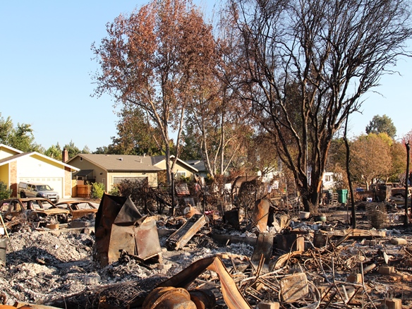
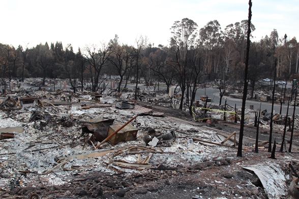
Figure 3. Remnants of the Fountaingrove neighborhood after the wildfire.
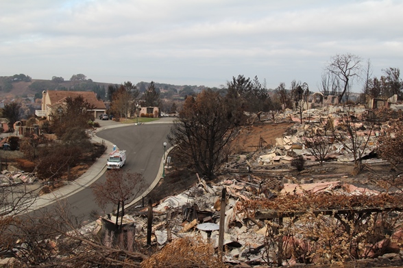
Figure 4. Homes damages by wildfire on Bellagio Court at the center of the Fountaingrove neighborhood.
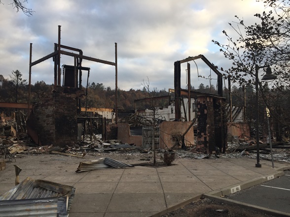
Figure 5. Remnants of a commercial plaza in the Fountaingrove neighborhood after the wildfire.
Most of Trione-Annadel State Park on the eastern edge of Santa Rosa is covered by forest. A number of paved roads were constructed along the hillside, connecting the Bennett Valley Road at the bottom of the hill with the top. We saw only a few exposures along the accessible road in the park. The occupied landscape mainly consists of single-family homes, wineries, and vineyards; these occupied structures are widely scattered in the forest. The earth was scorched intermittently all along the accessible road and up the hillside. The damage ratio for this area was between 40% and 70%.
Glen Ellen, a census-designated place (CDP) in Sonoma Valley with a 700+ population is a mixed-use historical neighborhood comprising restaurants, retail stores and single-family homes. Most of the damaged structures were concentrated on Warm Springs Road and O’Donnell Lane on the west side of the neighborhood. The rest of Glen Ellen was mostly untouched except for a few destroyed single-family homes and discontinuous scorched earth on streets in the north and southwest sides of town. This location recorded the lowest damage ratio of between 15% and 30%. Most of the businesses there were back up and running, but again third-party contractors were there cleaning up the damaged properties and repairing homes damaged by fire and smoke.
Napa Road goes through the Sonoma Wilderness Urban Interface (WUI) area (as shown in Figures 6 and 7) located in the heart of Sonoma County’s wine-growing region. On either side of Napa Road there are large vineyards, with winery buildings situated behind vineyards. Most of the wine grape crop for this year had been harvested before the fire. While several one-story light steel frame structures were destroyed by flames and a smattering of others suffered partial damage, all the main winery buildings in this area survived the wildfire. In addition, most of the vines appeared to be unscathed and only a small portion of vineyards at the edge had been scorched, although large swaths of forest surrounding the vineyards at various locations were charred. The damage survey team was told by personnel at the wineries that both the relatively open space of the vineyards and the extra moisture held by the live vines helped to create a natural firebreak.
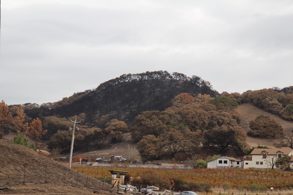
Figure 6. Charred forest near vineyards (foreground, between auto and buildings) in the Sonoma WUI area.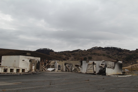
Figure 7. Historic dairy at the intersection of Napa Road and Freemont Drive in the Sonoma WUI.
The AIR damage survey team also examined a residential neighborhood on the west side of the Silverado resort. This moderately densely settled area consisted of large single-family homes. While not all of the area was accessible to the survey team, the particular area that was accessible had a damage ratio of approximately 60%. The golf courses on the east side of the development appeared to be undamaged and open for business.
ALERT subscribers can download a Touchstone-shapefile split into polygons that match areas surveyed by AIR from the Downloads tab on the ALERT website.