
M7.8 Turkey Earthquake
Status: Closed
| Type of posting | Posting date(EST): | Summary | Downloads |
|---|---|---|---|
| Post-Event Analysis | 2/14/2023 5:00:00 AM |
|
|
| Similar Stochastic Events | 2/6/2023 2:00:00 PM |
|
|
Similar Stochastic Events | Summary
Posting Date: February 6, 2023, 2:00:00 PM
A magnitude 7.8 (per the USGS) earthquake struck Turkey early Monday morning, just west of the city of Gaziantep, followed by a second major temblor registering at magnitude 7.5 per the USGS about 100 km to the north-northeast of the initial quake. The Kandilli Observatory in Turkey measured the initial quake with a Richter magnitude of 7.4 and a moment magnitude of 7.7, with the second quake coming it at a Richter magnitude of 7.5 and a moment magnitude of 7.6. Dozens of other aftershocks ranging as high as magnitude 6.7 have also been measured. The 7.8 magnitude of the initial quake, if confirmed, places it on par with the 1939 Erzincan event as the most powerful earthquake to strike Turkey on record.
ALERT™ subscribers can download similar stochastic event (SSE) IDs for this earthquake’s impacts from the Downloads tab of this posting on the ALERT website. Compatible with Touchstone® and Touchstone Re™, the SSEs were selected based on the quake’s key parameters such as location, magnitude, and focal depth. The selections are meant to capture the impacts of this series of earthquakes; we are not providing guidance or Event IDs for the M7.5 aftershock separately. The Event IDs provided are recommended for use with exposures in Turkey.
The quake has caused catastrophic damage and loss of life in Turkey and bordering areas of Syria. More than 2,300 deaths have already been reported, and that figure is expected to continue to rise in the coming hours and days. Official figures from the Turkish government on Monday morning placed the number of collapsed buildings in excess of 2,800 – that figure will also likely climb as aftershocks and damage assessment continue.
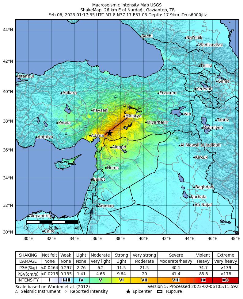
According to the USGS, the magnitude 7.8 earthquake resulted from strike-slip faulting at shallow depth. The preliminary location of the earthquake places it within the vicinity of a triple-junction between the Anatolia, Arabia, and Africa plates. The mechanism and location of the earthquake are consistent with the earthquake having occurred on either the East Anatolia fault zone or the Dead Sea transform fault zone, while aftershock distribution and seismic wave form inversion point to the East Anatolia fault as the most likely source The East Anatolia fault accommodates the westward extrusion of Turkey into the Aegean Sea, while the Dead Sea Transform accommodates the northward motion of the Arabia peninsula relative to the Africa plate.
The region where this earthquake occurred is seismically active. Three earthquakes of magnitude 6 or larger have occurred within 250 km of the February 6 earthquake since 1970. The largest of these, a magnitude 6.7, occurred northeast of the February 6 earthquake on January 24, 2020. All of these earthquakes occurred along or in the vicinity of the East Anatolia fault. Despite the relative seismic quiescence of the epicentral area of the February 6, southern Turkey and northern Syria have experienced significant and damaging earthquakes in the past. Aleppo, in Syria, was devastated several times historically by large earthquakes, though the precise locations and magnitudes of these earthquakes can only be estimated. Aleppo was struck by an estimated magnitude 7.1 earthquake in 1138 and an estimated magnitude 7.0 earthquake in 1822. Fatality estimates of the 1822 earthquake were 20,000-60,000.
With regard to the M7.5 aftershock, the USGS reported that the event ruptured either a near-vertical left-lateral fault striking east-west, or a right-lateral fault striking north-south with its epicenter located about 30-40 km off the main East Anatolia fault trace, reflecting the complex tectonic structure of the fault zone of the western boundary of the Anatolia microplate which the Arabia plate collides with the Anatolia plate The East Anatolia fault is a very wide active fault zone composed to series of faults and fault segments, which is typical tectonics of a collision zone.
Earthquake insurance in Turkey is compulsory for property owners, and is issued by DASK, the country’s Foundation for Natural Disaster Insurance, via the Turkish Catastrophe Insurance Pool (TCIP). Earthquake insurance in Turkey generally covers property features such as all primary walls, separating walls, garden walls, ceilings, floors, staircases, elevators, walkways, roofs, and property entrances. It also includes covering the costs of moving debris, lost wages or rental interruption, expenditures of relocating to a new house or new job, any losses arising from damage to furniture, baggage, and valuables, bodily and psychological damages, and fatalities if they are documented later in the case of damage. The policies are generally geared toward properties meant for residential use, such as flats, villas, and residential complexes, which are registered with the Turkish Land Registry Office. Policies treat any shaking within a 72-hour window as a single loss occurrence, and deductibles are typically set at 2% of insured value. Limits of coverage have increased sharply in recent years due to inflation, and as of the end of 2022 sat at 640,000 TRY. According to DASK, the insurance penetration rate in both the impacted area and the country at large is approaching 60%.
The Verisk ALERT and Earthquake modeling teams are studying this event and its ongoing impacts. We will provide an update on next steps before end of business Wednesday, February 8th.
Similar Stochastic Events | Downloads
Posting Date: February 6, 2023, 2:00:00 PM
The information provided herein is strictly confidential and is solely for the use of Verisk clients; disclosure to others is prohibited.
Similar Stochastic Event IDs
Note: These lists give event IDs taken from our stochastic catalog that have similar characteristics as the current event.
| Product | File Type | Description | Download |
|---|---|---|---|
| TOUCHSTONE / Re | Excel (xls) | Selected set of stochastic events, with Readme in Excel format | |
| TOUCHSTONE / Re | CSV (csv) | Selected set of stochastic events, formatted for import into Touchstone/Re |