More Flooding in Germany
Status: Closed
| Type of posting | Posting date(EST): | Summary | Downloads |
|---|---|---|---|
| Custom Events | 6/18/2024 4:00:00 AM |
|
|
| Shapefile | 6/5/2024 3:00:00 PM |
|
|
| Monitoring | 6/3/2024 12:00:00 PM |
|
Custom Events | Summary
Posting Date: June 18, 2024, 4:00:00 AM
Verisk estimates that insured industry losses from the flooding in Germany over the period 15 May to 5 June will range from EUR 2.4 billion (USD 2.6 billion) to EUR 3.6 billion (USD 3.9 billion).
ALERT™ subscribers can now download Touchstone® and Touchstone Re™ event sets, loss-based similar stochastic events (SSEs), and a shapefile of the median modeled flood extents from the Downloads tab for this posting on the ALERT Website. The loss-based SSEs are recommended only for exposures in Germany. The information provided herein is strictly confidential and is solely for the use of Verisk clients; disclosure to others is prohibited unless noted in your Verisk software license.
Modeling Assumptions
To produce the loss estimates, the Verisk flood team analyzed hourly precipitation fields over Germany derived from NASA’s Global Precipitation Measurement (GPM) system during May 15 to June 5. Daily observed rainfall data from Hydrometeorologischer Rasterdatensatz Niederschlag für Deutschland (HYRAS-DE-PRE), obtained from the Climate Data Center at Deutscher Wetterdienst (DWD), was also assimilated to improve the quality of the GPM precipitation input. As the vast majority of losses for this event within Germany came from the catchments of the Rhine and Danube basins, the spatial extent of this event set, posted through Verisk’s ALERT service, is limited to these two river basins within Germany. Perturbations based on the spatial correlation in precipitation accumulations were introduced to the adjusted precipitation fields to generate a large set of precipitation scenarios and, thus, to quantify the uncertainty associated with the precipitation input. This ensemble of precipitation fields (a total of 50 scenarios) was then used to model runoff and river flow.
River flow data from approximately 770 gauging stations in the Rhine and Danube River basins within Germany, obtained from country’s provincial and federal agencies, was used to calibrate and validate the modeled flows. Each precipitation scenario generated a loss scenario resulting in an ensemble of loss estimates. Based on the estimated loss pattern across Germany, five scenarios from the ensemble catalog were selected to represent the range of estimated losses. These five scenarios have been posted to the ALERT website.
Verisk’s loss estimates include:
- Verisk’s assumed take-up rates and exposure indexing in Germany
- Insured physical damage to property (residential, commercial, industrial, auto, agriculture), both structures and their contents, from both on- and off-floodplain flooding
- Additional living expenses (ALE) for residential claims and business interruption (BI) for commercial claims
Verisk’s loss estimates do not include:
- Losses outside of Germany
- Losses to uninsured properties
- Losses to infrastructure
- Losses from extra-contractual obligations
- Losses from hazardous waste cleanup, vandalism, or civil commotion, whether directly or indirectly caused by the event
- Demand surge
- Other non-modeled losses
Event Summary
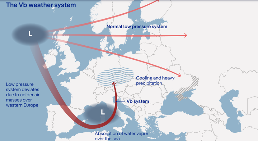
The excessive rainfall that drove this event (itself dubbed “Orinoco” by Germany’s Federal Agency for Technical Relief) was caused by what is classified as a Vb (“5-b”) weather event, originally termed as such by German meteorologist Wilhelm Jacob van Bebber in 1891, one of five classifications of European storms he coined at that time. In this setup, colder air over Europe drives these low-pressure systems southward toward the Mediterranean Sea as they approach the continent. A Vb system then picks up warm, humid air from over the Mediterranean, leading to prolonged and intense rainfall as it tracks back northward. The continent-spanning flooding of 2002 - which also caused significant impacts in Germany - was also driven by this Vb setup, shown in the image below:

Setup and Track of a “Vb” Weather System (Deutscher Wetterdienst)
Between Friday 31 May at noon and Monday 3 June at noon, 120 to 160 liters of rain fell per square meter across southern Germany, which is more than usually falls in a month, according to Sebastian Altnau, a meteorologist with the German Weather Office. The main flooding ultimately occurred along parts of the upper Danube River, as well as several of the Danube's southern tributaries, with the worst impacts in Germany in Bavaria and Baden-Württemberg. The flooding submerged streets, highways, homes, and businesses. A dam on the Paar River broke in two places in the Bavarian district of Pfaffenhofen an der Ilm, severely flooding surrounding areas and requiring hundreds to evacuate in nearby Baar-Ebenhausen. A dyke and a dam also broke in Diedorf.

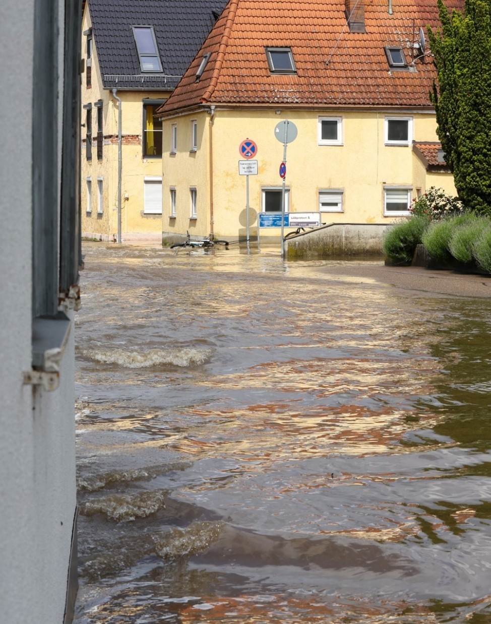
Flooding in Günzburg, Bavaria (Government of Bavaria/StMI/Alexandra Beier)
Elsewhere in Bavaria, the Schmutter, Cham, Paar, Ilm, Danube and Isar all reached above the level 4 (highest) warning levels in several locations. A state of emergency was declared in several districts and cities in Bavaria, including Günzburg, Augsburg, Aichach-Friedberg, Neu-Ulm, Pfaffenhofen an der Ilm, Donau-Ries, Unterallgäu, Freising, Neuburg-Schrobenhausen, Dillingen ad Donau, Dachau, Kelheim, Deggendorf and Straubing-Bogen, as well as the cities of Straubing and Regensburg. In Baden- Württemberg, homes and businesses were also flooded, and an estimated 95,000 hectares of farmland were inundated.
A relatively high proportion of the overall losses for this event are likely to be insured, owing to the high insurance take up for the flood peril in the region most affected, though the bill picked up by the insurance industry will differ by region. According to the German Insurance Association (GDV), nearly half of all structures in Bavaria are insured for flood, while in Baden-Württemberg that figure exceeds 90%, as it was a compulsory part of property insurance in that state until 1994.
No additional ALERT activity for this event is currently planned. Please contact your Verisk representative with any additional questions.
Custom Events | Downloads
Posting Date: June 18, 2024, 4:00:00 AM
The information provided herein is strictly confidential and is solely for the use of Verisk clients; disclosure to others is prohibited.
Simulated Event Sets
These event sets contain five custom modeled scenarios for the recent flooding in Germany.
User Note: Demand Surge for Europe is not currently supported for ALERT event sets in Touchstone v11.5. Analyses run with this event set in Touchstone v11.5 should have demand surge switched off.
| Product | Description | Download |
|---|---|---|
| Touchstone Re | Selected set of simulated scenarios | |
| Touchstone | Selected set of simulated scenarios |
Loss Based Similar Stochastic Event IDs
These stochastic events were selected as best matches to the insured industry loss footprints generated by the custom modeled scenarios in the Simulated Event Set
Additional Downloads
Note: Additional downloads related to the posting are listed below. Please use the appropriate application to view these files.
| Title | File Type | Description | Download |
|---|---|---|---|
| Shapefile of Median Modeled Flood Extent | .zip | A shapefile for the median loss scenario flood footprint from the Simulated Event Set |