
More Flooding in Germany
Status: Closed
| Type of posting | Posting date(EST): | Summary | Downloads |
|---|---|---|---|
| Custom Events | 6/18/2024 4:00:00 AM |
|
|
| Shapefile | 6/5/2024 3:00:00 PM |
|
|
| Monitoring | 6/3/2024 12:00:00 PM |
|
Shapefile | Summary
Posting Date: June 5, 2024, 3:00:00 PM
Flooding continues in southern Germany and is spreading along the Danube into Austria and Hungary. Five people have died thus far, thousands have been evacuated, and transport disruption continues.
ALERT™ subscribers can download shapefiles created from data published by the Copernicus Emergency Management Service Rapid Mapping product for this event (EMSR728) from the Downloads tab, which can be utilized within the Touchstone® Geospatial Analytics Module or any GIS application to better understand the extent and impacts of this event.
ALERT subscribers can also download lists of CRESTA zones and 5-digit postal codes which intersect with the previously released Copernicus Emergency Management Service data derived shapefile from the Downloads tab of this posting on the ALERT website. The files list the total area for each geographic designation, as well as the total and percent of that area within the Copernicus footprint.
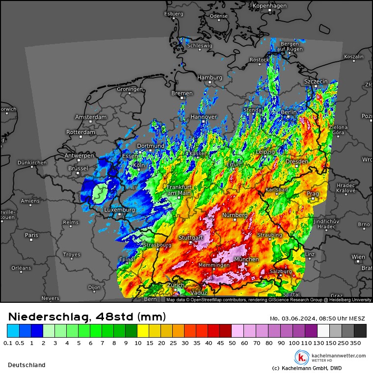
In addition, ALERT subscribers can download tables of average total precipitation values (in mm) across CRESTA zones and 5-digit postal codes intersecting the two primary German states of interest (Bavaria and Baden-Wurteemberg). The underlying dataset is the 1-km gridded daily precipitation observations provided by the Deutscher Wetterdienst (DWD) by the name of Hydrometeorologischer Rasterdatensatz Niederschlag für Deutschland (HYRAS-DE-PRE): https://www.dwd.de/DE/leistungen/hyras_de_pre/hyras_de_pre.html?nn=567550. The accumulation period spans last 21 days ending at 2024-05-06 08:00:00 CEST. The period covers both recent floods and the previous flooding impacts around May 17.
The set up that led to the precipitation which caused this event started with two slow-moving, blocking areas of high pressure. One of these was located over north-west Russia; at the same time, another high pressure area extended across the eastern Atlantic to northern Spain. Wedged between them, a low-pressure trough formed from northern Italy to the Baltic Sea. The interplay of warm and very humid air masses from the Mediterranean region and cool North Atlantic air caused heavy and prolonged precipitation in the border area.
Impacts have been widespread across southern Germany. In Bavaria, the main flooding concerns have increasingly concentrated on the Danube, which saw warning level 4 (highest level) reached in many locations. The positive news for this section of the Danube is that flood waters are expected to recede as this week progresses. Elsewhere, in Baden-Wurttemberg, 100-year floods have been observed at the Gollsdorf gauging station on the Prim tributary of the Neckar, the Haubersbronn gauging station on the Wieslauf tributary of the Rem, and Leutenbach station on the Buchenbach tributary of the Mur. 10- and 15-year floods have also been observed at Heidelberg and Gundelsheim on the Neckar, respectively. In Reichertshofen, two dams broke despite being fortified with sandbags, allowing the Baar to flood nearby neighborhoods. The Upper Rhine (5-to-10-year flooding at Maxau and Worms) and Paar (more water discharged than a 100-year flood) have also seen impacts.

Flooding in Passau from the Danube (Michael Stache/AFP)
Disruptions in shipping and railway operations in parts of Germany continued Tuesday, particularly in the states of Bavaria and Baden-Wuerttemberg. Deutsche Bahn long-distance routes and local traffic in Bavaria were severely affected, but since Tuesday morning long-distance traffic has been able to reach Munich from the north again, Germany's railroad operator said. Germany's waterways and shipping office said all shipping is suspended in the area from the upper Rhine, which includes Mainz, to the middle Rhine near Koblenz, a major shipping route. Rail freight traffic in southern Germany has also been disrupted, particularly on the routes to and from Munich and Upper Bavaria. Auto produce Audi has suspended production at its Bavarian plant in Ingolstadt because of flooding from the Danube.
The Verisk ALERT and Flood teams continue to monitor this event, and will provide an update on additional plans, if any, later this week. In the meantime, please contact your Verisk representative with any additional questions about this event.
Shapefile | Downloads
Posting Date: June 5, 2024, 3:00:00 PM
The information provided herein is strictly confidential and is solely for the use of Verisk clients; disclosure to others is prohibited.
Shapefile and Affected Areas Downloads
Note: Downloads related to the posting are listed below. Please use the appropriate application to view these files.
| Title | File Type | Description | Download |
|---|---|---|---|
| Copernicus Observed Event Area | .zip | Combined Copernicus EMS Observed Event Areas (as of 4th June) Shapefile with instructions for import into Touchstone | |
| Affected CRESTA Zones | .xlsx | A list of CRESTA zones which intersect with the shapefile above, along with the amount of area and percentage of that total area within the footprint per CRESTA | |
| Affected Postal Codes | .xlsx | A list of 5-digit postal codes which intersect with the shapefile above, along with the amount of area and percentage of that total area within the footprint per postal code | |
| 21-day Average Precipitation by CRESTA | .csv | Average total precipitation values (in mm) by CRESTA zone intersecting the two primary German states of interest (Bavaria and Baden-Wurttemberg) | |
| 21-day Average Precipitation by Postal Code | .csv | Average total precipitation values (in mm) by 5-digit postal code for the two primary German states of interest (Bavaria and Baden-Wurttemberg) |