Hurricane Otis
Status: Closed
| Type of posting | Posting date(EST): | Summary | Downloads |
|---|---|---|---|
| Post-Landfall | 11/1/2023 9:00:00 AM |
|
|
| Similar Stochastic Events | 10/25/2023 11:00:00 AM |
|
|
Post-Landfall | Summary
Posting Date: November 1, 2023, 9:00:00 AM
Verisk estimates industry insured losses to onshore property for Hurricane Otis will likely fall from MXN 50 billion to MXN 110 billion (~USD 3 billion to 6 billion). The industry loss range includes estimated wind and precipitation-induced flood across Otis’ track. Most of the modeled loss is attributable to wind. Sources of uncertainty in the modeled loss estimate include the amount of insurance take up and insurable exposure values in the affected region, the potential for increased business interruption losses due to widespread damage to infrastructure and heavy reliance on tourism for the local economy, and the impact of any government insurance schemes.
ALERT™ subscribers can now download Touchstone® and Touchstone Re™ event sets, loss-based similar stochastic events (SSEs), and a shapefile of the median wind footprint from Hurricane Otis from the Downloads tab for this posting on the ALERT Website. The loss-based SSEs are recommended only for exposures in Mexico. The information provided herein is strictly confidential and is solely for the use of Verisk clients; disclosure to others is prohibited unless noted in your Verisk software license.
Modeling Information and Assumptions
Included in the industry insured loss estimate are losses to onshore residential, commercial, and industrial properties and automobiles for their building, contents, and time element coverage from wind and precipitation induced flood. The underlying indexed industry exposure values are as of December 31, 2022. See below for additional information.
Verisk’s modeled insured loss estimates do not consider:
- Losses paid out by any sovereign or government protection programs
- Losses from coastal storm surge
- Losses to inland marine, ocean-going marine cargo and hull, and pleasure boats/yachts
- Losses to uninsured properties
- Losses to infrastructure
- Losses from extra-contractual obligations
- Losses from hazardous waste cleanup, vandalism, or civil commotion, whether directly or indirectly caused by the event
- Loss adjustment expenses
- The impact of demand surge
Meteorological History of Otis
Hurricane Otis first became a tropical depression on October 22, with the forecast at the time anticipating it not reaching hurricane strength nor reaching land. By that night, Otis was a tropical storm and landfall was anticipated along the Pacific coast of Mexico, prompting Tropical Storm Watches. At 1:00 am local time Tuesday, Otis remained a tropical storm with maximum sustained winds of 50 mph. As Otis continued to strengthen that morning, the official forecast was increased to bring the cyclone to hurricane intensity by landfall, and with the expectation that the NHC Hurricane Hunter aircraft would visit the storm that afternoon to confirm its intensity. The flight found the storm nearing major hurricane (Saffir-Simpson category three or higher) intensity early that afternoon, with maximum sustained winds now at 110 mph.
Otis continued to intensify at a remarkable pace over the next several hours, reaching Saffir-Simpson category five status by 11:00 pm local time - meaning Otis had increased its maximum winds by 115 mph in just 25 hours. Otis made landfall two and a half hours later with maximum sustained wind estimates of 165 mph. Interaction with the mountainous terrain of southern Mexico quickly dissipated Otis as it moved inland, and by 4:00 pm on Wednesday the National Hurricane Center had downgraded Otis to a tropical depression and issued its final advisory on the storm – just fifteen hours after it reached the Pacific coast of Mexico as the strongest landfalling hurricane on record, and the fourth most intense in the nation’s history.
Hazard and Damage Observations
Few wind measuring stations survived the storm and provided reliable data on wind speeds. One station near Acapulco which did make it through the storm recorded a peak wind gust of 135 mph. Observations from aircraft as well as satellite data were used to help constrain the modeled wind field. Maximum rainfall amounts along the coast generally fell between 8 and 12 inches, with a widespread 2+ inches across much of the state of Guerrero.
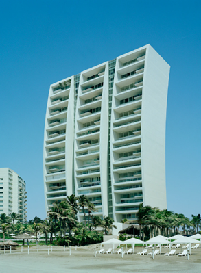
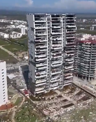
The coastline of Acapulco contains many larger apartment and condominium buildings as well as hotels. Many of those had a majority of windows blown out by Otis’ devastating winds. Roof covering damage was also noted on many buildings near the coast. Smaller commercial and residential buildings in Acapulco saw major damage as well, with cladding tossed from walls, roofs torn off, and debris scattered. To the north and west of Acapulco, significant damage was also observed. In Coyuca de Benitez, Guerrero, there was minor damage to a hospital as well as significant damage to residential structures observed. The before and after shots shown below provide a visual representation of the massive damage inflicted on several commercial properties in the vicinity of Acapulco including condominiums, hotels, to mention a few.
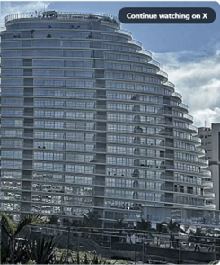
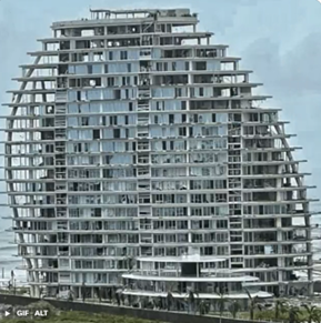
Before (left) and after (right) photos of a new luxury high rise condominium building in Acapulco severely damaged by Hurricane Otis (Source: X (formerly Twitter))
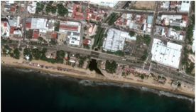
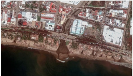
Before (left) and after (right) aerial images showing the extent of wind and water damage along the coast in Acapulco (Source: Reuters)
Before (left) and after (right) photos of massive destruction to the components and cladding, interior building components and contents in a high-rise condominium complex in Acapulco (Source: Reuters, X (formerly Twitter))
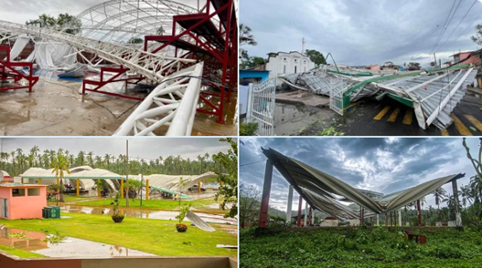
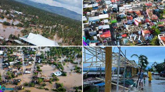
Moderate to heavy wind and flood damage to residential and commercial establishments in Coyuca de Benitez, Guerrero from Hurricane Otis
Role of Building Codes in Explaining Wind Damage Caused by the Hurricane
Damage to coastal and inland exposures in and around Acapulco was catastrophic. While some essential or critical facilities, such as hospitals and schools, consider 200-year return period winds for wind design, most commercial and residential buildings consider a 50-year return period design wind, which translates to 88 mph design wind speeds. These were well exceeded for much of Acapulco and surrounding areas during Hurricane Otis. This region is considered to be in the high seismic risk zone per the Mexico Building Code and therefore seismic design tends to be the governing design criterion for buildings. Seismic design considerations involve provision of light cladding with lower mass as it translates to lower seismic forces. However, this meant for an event like Otis that a wide majority of engineered buildings experienced cladding and envelope failure. Had these skin elements not failed, the full wind forces would have been transferred to the main wind force resisting (structural) system, which would have survived if design seismic forces are larger than hurricane wind forces.
The Insurance Market in Mexico
Mexico is the second largest insurance market in Latin America, behind only Brazil in terms of gross written premiums. Premium growth in the non-life sector has generally been steady over the past decade, though this trend has slowed due to the COVID-19 pandemic as well as inflation. To control inflation, the Bank of Mexico raised interest rates in March 2023. During 2022, the prices of residential properties increased due to a rise in costs of raw materials and labor costs. The high-interest rates have led to high mortgage rates, decreasing potential buyers’ purchasing power. This has slowed the sale of properties and consequently reduced the growth of property premiums in 2022. The trend in slower growth of premiums is expected to continue in 2023.
The market is fairly concentrated, with the top five insurers making up a bit less than half of the market, and the top ten covering approximately two-thirds. Grupo Nacional was the leading general insurer in 2022 in terms of gross written premium, followed by AXA Seguros and Qualitas Compania de Seguros. As Mexico permits foreign direct investments, foreign companies can operate in Mexico through the establishment of a branch or wholly or partially owned subsidiary. State insurer Agroasemex, primarily a major agricultural insurer in the country, also insures a significant proportion of government buildings. Insurance take up for residential risks is quite low in Mexico, though quite a bit higher for commercial risks. However, it is likely there is higher residential insurance take up in Acapulco, in particular direct coastal areas, than across the rest of the state of Guerrero.
This is the final ALERT planned for Hurricane Otis. Please contact your Verisk representative with any additional questions about this event.
Post-Landfall | Downloads
Posting Date: November 1, 2023, 9:00:00 AM
The information provided herein is strictly confidential and is solely for the use of Verisk clients; disclosure to others is prohibited.
Simulated Event Sets
These event sets contain five custom modeled scenarios for Hurricane Otis, allowing for uncertainty in key model parameters such as radius of maximum winds and central pressure. All scenarios follow the official NHC track.
| Product | Description | Download |
|---|---|---|
| Touchstone | Selected set of simulated scenarios | |
| Touchstone Re | Selected set of simulated scenarios |
Loss Based Similar Stochastic Event IDs
These stochastic events were selected as best matches to the insured industry loss footprints generated by the custom modeled scenarios in the Simulated Event Set
Additional Downloads
Note: Additional downloads related to the posting are listed below. Please use the appropriate application to view these files.