Hurricane Idalia
Status: Closed
Custom Event Sets | Summary
Posting Date: September 4, 2023, 5:00:00 AM
Verisk estimates industry insured losses to onshore property for Hurricane Idalia will range from USD 2.5 billion to USD 4 billion. The industry loss estimate includes estimated wind and insured estimates of storm surge across Idalia’s track. Most of the loss is attributable to wind.
ALERT™ subscribers can now download Touchstone® and Touchstone Re™ event sets, loss-based similar stochastic events (SSEs), and wind and surge shapefiles of the median event for the wind and storm surge impacts from Hurricane Idalia from the Downloads tab for this posting on the ALERT Website. The loss-based SSEs are recommended only for exposures in Florida, South Carolina, North Carolina, and Georgia. The information provided herein is strictly confidential and is solely for the use of Verisk clients; disclosure to others is prohibited unless noted in your Verisk software license.
Modeling Information and Assumptions
Included in the industry insured loss estimate are losses to onshore residential, commercial, and industrial properties and automobiles for their building, contents, and time element coverage, as well as the impact of demand surge. The underlying industry exposures are as of December 31, 2022.
Storm surge losses quoted in the industry loss estimate are reflective of 5% leakage assumptions on wind only policies for residential, renters, manufactured homes and small commercial, industrial, commercial residential risks, and 100% coverage on larger commercial, industrial and commercial residential risks and automobiles. Touchstone users who wish to test the sensitivity of these assumptions to their own modeled losses may adjust the leakage factors by line of business when setting up analyses.
Further discussion of the impact of current market conditions can be found in the ‘Other Considerations’ section of this summary.
See below for additional information.
Verisk’s modeled insured loss estimates do not include:
- Losses paid out by the National Flood Insurance Program
- Losses exacerbated by litigation, fraudulent assignment of benefits, or social inflation
- Storm surge leakage losses paid on wind only policies due to government intervention
- Losses from precipitation-induced flooding
- Losses to inland marine, ocean-going marine cargo and hull, and pleasure boats
- Losses to uninsured properties
- Losses to infrastructure
- Losses from extra-contractual obligations
- Losses from hazardous waste cleanup, vandalism, or civil commotion, whether directly or indirectly caused by the event
- Losses resulting from the compromise of existing defenses (e.g., natural and man-made levees)
- Loss adjustment expenses
- Other non-modeled losses, including those resulting from tornadoes spawned by the storm
- Losses for U.S. offshore assets and non-U.S. property
Meteorological History of Idalia
On the afternoon of Saturday, August 26th, a near-stationary low-pressure system located near the northeastern Yucatan Peninsula began showing signs of better organization, prompting the National Hurricane Center (NHC) to designate the system Tropical Depression Ten. In an environment lacking steering flow, the system remained relatively idle overnight; tracking slightly southward at a pedestrian 5 mph as dawn arrived on Sunday, August 27th. Continued weak steering currents resulted in little net motion on Sunday; but deep warmth present in the northwestern Caribbean fostered gradual strengthening throughout the day and lifted the storm to tropical storm strength, making Idalia the tenth storm to reach tropical storm status this year (including an unnamed storm in January). Idalia continued to aimlessly meander around the northwest Caribbean going into Sunday evening, at one point becoming entirely stationary overnight.
In the pre-dawn hours of Monday, August 28th, Idalia began its trek northward between a mid-level trough to the east (over the central Gulf of Mexico) and a strengthening ridge to the west (over the Greater Antilles). Progress was kept at a modest 8 mph as the storm brushed past west Cuba and emerged into the eastern Gulf of Mexico. Owing to its proximity to land and lack of forward speed, Idalia brought heavy rainfall to the eastern Yucatan Peninsula and western Cuba for over 36 hours, resulting in significant flooding. The land interaction with Cuba did not weaken Idalia so much as it restrained additional growth, illustrating how potent an environment the storm was tracking through. Before dawn on Tuesday, August 29th, Idalia’s intensification resumed as the storm developed the makings of an eyewall and was elevated to hurricane strength.
Idalia then began to accelerate its northward pace to a brisk 14 mph, entering a region of the Gulf of Mexico with 87° F sea-surface temperatures and weakening shear while the system was still about 36 hours from landfall. As a result, Idalia underwent rapid intensification all day Tuesday and overnight into Wednesday, August 30th. Idalia began its anticipated, subtle turn clockwise Tuesday evening, putting it on a north-northeasterly track that aimed the system’s center at Apalachee Bay in the heart of Florida’s Big Bend region, an area which has never seen a major hurricane in recorded history (i.e., since 1851). At dusk on Tuesday, Idalia was a high-end Category 2 hurricane with sustained winds of 105 mph; by dawn on Wednesday, the system was a powerful, low-end Category 4 hurricane with sustained winds of 130 mph. Immediately prior to landfall, Idalia began an eyewall replacement which weakened the core of the storm slightly. At 7am on Wednesday morning, NHC Hurricane Hunter aircraft data indicated that Idalia’s maximum sustained winds had dipped slightly to 125 mph, or strong Category 3 strength. While falling 5 mph short of Category 4 status, this downgrade made a negligible difference to the amount of wind damage Idalia would go on to cause. At around 7:45am EDT, Hurricane Idalia made landfall in Taylor County within Florida’s Big Bend region, near Keaton Beach, as a Category 3 hurricane with a minimum central pressure of 949 mb.
Idalia’s outer rain bands began to arrive in south Florida on Tuesday morning, bringing 2 to 4 inches of rainfall to a portion of Florida’s Gulf Coast stretching from Lee County to Manatee County and loosely following Route 17 inland as far inland as central Polk County. Thunderstorms in one of the stronger bands spawned at least one tornado that touched down in Highlands County. Meanwhile, wind speeds along the coast ticked upward through the day as Idalia tracked northward about 100 miles offshore of Florida’s west coast, becoming tropical-storm-strength for points north of Sarasota County by Tuesday evening into the overnight hours. After midnight on Wednesday morning, storm surge began to encroach into Gulf Coast bays and estuaries including Tampa and Punta Gorda as well as locations closer to the landfall point in the Big Bend region of Florida. Moderate flooding conditions occurred in coastal and low-laying parts of St. Petersburg and Tampa on Wednesday.
While Idalia made landfall in a sparsely populated region of Florida, catastrophic damage was observed in small communities like Perry, which took the brunt of the storm’s fierce western eyewall shortly after landfall, and Cedar Key, which experienced historic storm surge inundation. Fortunately, Tallahassee was largely spared from the worst as the storm’s center passed 60 miles to the east and saw 3 inches of rainfall and wind gusts into the 40s mph.
Idalia’s forward speed increased to 20 mph as it interacted with a cold front sweeping eastward across the Southeast, bringing the now Category 1 storm over the state boundary into Georgia near Valdosta around 11am local time. Incidentally, the trailing front effectively wrung out much of Idalia’s tropical moisture as it tracked northeastward through the Southeast, more or less parallel to the Atlantic coast. Significant damage was observed in Valdosta, where remnants of the western eyewall deluged the area with 6 inches of rain and brought powerful winds. As a result, widespread flooding and considerable structural and roof damage ensued. By late afternoon, the center of speedy Idalia had moved into southeastern South Carolina and weakened to a tropical storm with maximum sustained winds of 70 mph and a wind field reaching well inland. Idalia’s northeast track led the storm offshore in the early morning of Thursday, August 31st. While located offshore, Idalia brought tropical-storm-force winds, heavy rain, and powerful surf to the North Carolina coast. Rainfall totals between 6 to 8 inches were observed from Statesboro, Georgia to eastern North Carolina.
Validation of the Verisk’s Modeling of Idalia
Wind and Storm Surge Damage
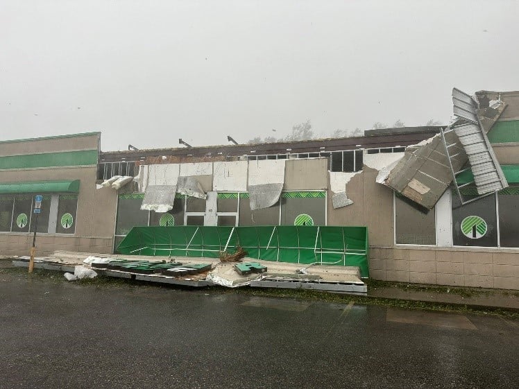
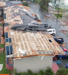
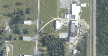
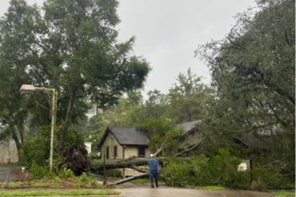
Wind damage in varying degree was observed in all the areas impacted by Hurricane Idalia’s windfield. Damage was more severe in and around the areas where Idalia made landfall in the Big Bend region of Florida including Taylor and Suwanee counties. It ranged from significant loss of roof covers in residential homes to torn up roof membranes in commercial structures, as shown in the figures below. Extensive damage is also seen to elements of building components and cladding.
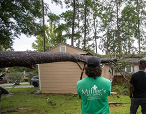
Varying levels of damage inflicted by fallen trees was observed along the path of Idalia. Cities including Tallahassee, Gainesville, Jacksonville, FL; Valdosta, Savannah, GA are reporting a large number of downed trees. This area is also dominated by large pine trees, and these can lead to costly cleanup costs, roof replacements and associated costs especially if they were to fall on nearby homes. Similar phenomenon was seen in the aftermath of 2018 Hurricane Michael in the city of Tallahassee where losses in excess of 1 Bn were seen and driven primarily by tree related damage. However, Hurricane Michael was much stronger than Idalia in its closest approach to Tallahassee. Manufactured homes constitute a significant portion of the residential inventory in Big Bend region of Florida when Idalia made landfall. Several manufactured homes in these areas saw massive damage including loss of roofs, damage to wall siding and near total destruction due to wind and surge alike, the latter in coastal areas.
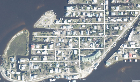
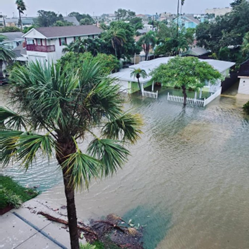
Storm surge produced significant damage in the coastal neighborhoods of Keaton Beach, Steinhatchee, Horseshoe Beach and Cedar Key, FL. Residential homes founded on slabs saw significant water related damage to various building components and contents. Beachfront homes elevated on piles/stilts performed relatively well. Manufactured homes were washed away due to the dynamic impact of fast-moving coastal surge. Flooding along the waterfront areas were reported in and around Tampa, St. Petersburg, FL, and Charleston, SC.
Putting Damage in Perspective from the Context of Building Codes
Florida has a long history when it comes to the evolution and adoption of building codes. Right from its very first adoption of the statewide building code in 2002, it has been a pioneer nationally in wind design specifications. The Big Bend region of Florida where Idalia made landfall has the lowest design winds statewide, between 120 and 130 mph. Furthermore, areas along the coast and inland are excluded from the wind-borne debris region, which means opening protection and stronger opening requirements are not required in the buildings in this region. The same is true for southwestern parts of Georgia that experienced strong winds from Idalia. Further, a major hurricane similar to Idalia has not impacted this region for over 125 years. The last major hurricane to make landfall in the Big Bend Region of Florida would be the unnamed hurricane in 1896. A significant portion of the building inventory along the track of hurricane Idalia predate the International Codes - i.e., are built prior to the year 2000. As noted previously, hurricane Idalia made landfall in this region with 125 mph sustained winds. Owing to the aforementioned factors, the damage is expected to be severe in the vicinity of landfall.
Other Considerations
Litigation, Social Inflation, Assignment of Benefits
Social inflation and assignment of benefits remain potential drivers of higher than expected losses. Both phenomena have been seen in recent catastrophe events in Florida. Social inflation impacts have generally been most prevalent in recent years in commercial auto, liability, and medical malpractice claims, but remains a potential factor in losses from Idalia. The Florida Legislature passed significant bills in 2019 and 2022 aimed at curbing some of the worst abuses of the assignment of benefits (AOB) and social inflation, though it remains to be seen how effective these will be in limiting additional losses due to litigation. Litigation remains outstanding from Hurricane Ian last year, though so far, the overall impacts of these phenomena on that event’s loss have not been as great as the industry’s worst fears. Setting litigation and AOB aside, not all claims stemming from 2022 Hurricane Ian have been closed. Recent data from the Florida Office of Insurance Regulation (FLOIR) show that approximately 16% of claims statewide from residential homeowners and close to 10% of claims statewide from manufactured homes are still open. The statistic is close to 12% open claims when considering the counties in the vicinity of hurricane Idalia’s track. Another factor that could exacerbate claims somewhat from this event is the lack of recent major weather events in this region. There is a chance that some homeowners could file claims for previous wear or damage not caused by the hurricane, which could drive somewhat higher losses overall.
Inflation and Demand Surge
While construction costs have increased dramatically since the onset of the COVID-19 pandemic for a variety of reasons, data from Verisk Property Estimating Solutions indicate overall construction costs have started to level out in 2023, in part due to reduced demand and fewer supply chain bottlenecks, and also likely in response to the Federal Reserve’s aggressive raising of interest rates in an effort to cool inflation overall. An uptick in lumber costs was noted following the wildfires in Canada, but as of now it does not appear this will have a major impact on prices going forward. Labor costs have risen in 2023 as well, but not at the same pace as during the pandemic. Finally, relative to last year’s Hurricane Ian, Idalia has impacted far fewer buildings, meaning the overall stresses on the construction industry should be far less as rebuilding gets underway in the coming weeks and months.
National Flood Insurance Program
The flood insurance take-up on residential risks in Florida are low. According to a study by Milliman, less than a fifth of homeowners have coverage through the National Flood Insurance Program. Within those counties, homes inside the government-designated floodplain, the area most exposed to flooding, 47 percent of homes have flood insurance, Milliman found (across the entire state, the proportion is a similar 49%). In areas outside the floodplain, only an estimated 9 percent of homes have flood coverage.
Homeowners who choose to purchase flood insurance most commonly do so through the National Flood Insurance Program (NFIP), and Florida has the highest proportion of NFIP policies of any state – about 35%, according to Fitch Ratings. These policies typically cover up to $250,000 in damages and do not include additional living expense coverage, suggesting that even for some homeowners with flood insurance, there may be a gap between coverage and rebuilding costs.
Other Verisk Resources for Hurricane Idalia
Aerial Imagery of Impacted Areas
Vexcel Data Program, the world’s largest aerial imagery program, is providing Verisk high-resolution aerial imagery and damage assessment on buildings and properties impacted by Hurricane Idalia. Vexcel, along with its partner the Geospatial Insurance Consortium (GIC), have activated a full response to Hurricane Idalia by deploying multiple fixed-wing aircraft to collect high-resolution aerial imagery. Imagery is captured with Vexcel’s market-leading cameras then put through its world-class processing pipeline and delivered within 24 hours post-collection. This Gray Sky disaster imagery will help Verisk customers better understand which properties are affected and to what degree.
Machine learning (ML) is applied to Vexcel’s aerial imagery within hours of being published. The output is a full damage assessment on properties impacted by Hurricane Idalia by comparing recent aerial images with current disaster imagery. The data includes an overall Post Catastrophic score, approximate FEMA classification, and other roof damage attributes. These property-level details will cover every property that falls within Vexcel’s post-CAT collection area.
Using this imagery and data analytics, end users can:
- Better manage and scale responses to heavily impacted customers
- Proactively identify policy holders with damaged property and begin the claims process immediately
- Deploy resources, i.e., field adjusters, more effectively and safely with detailed information for remote assessment on damaged structures
- Pinpoint key learnings to shore up underwriting and risk policies for future events
Verisk Respond Hurricane Data
Verisk’s Respond Hurricane solution uses a multi-input model to provide a comprehensive and accurate view of tropical cyclone winds. The solution couples a five-day forecast of wind with a post-event view to provide a full wind field understanding of the impacts that have already occurred alongside the potential impacts that have yet to occur from a tropical system. The Respond Hurricane solution updates every six hours for any named storm in the Atlantic Ocean basin. Wind information is expressed both in terms of one-minute sustained wind speeds as well as three-second wind gusts. In addition, wind speed durations of 39 mph or greater (tropical storm force), 50 mph or greater, and 74 mph or greater (hurricane force) are also conveyed to provide a more comprehensive understanding of the wind threat.
In the event of a landfalling U.S. hurricane, within 24 hours of downgrade of the system to a tropical depression or post-tropical system, the Verisk Respond Hurricane maximum wind gust data are corrected by assimilating actual wind observations from multiple sources into the wind field to bias and error correct the modeled estimate. Special consideration is taken in this process to ensure the wind observations being incorporated accurately reflect the conditions at the location at a 10-meter height. This final maximum wind gust field will not only more closely match the assimilated observations, but final wind field values will be more accurate in general across the entire wind field, although typical differences between the modeled estimates and the observation-corrected post-storm are 10% or less.
A sample of Respond Hurricane data was shared with ALERT subscribers on Thursday, August 31. More information and the shapefile can be found here.
Please contact your Verisk representative for more information on either of these solutions.
Additional Plans for Idalia
The Verisk ALERT and Hurricane Modeling teams will continue to study the impacts of Idalia; however, no additional ALERT is currently scheduled. Please contact your Verisk representative with additional questions about this event.
Custom Event Sets | Downloads
Posting Date: September 4, 2023, 5:00:00 AM
The information provided herein is strictly confidential and is solely for the use of Verisk clients; disclosure to others is prohibited.
Simulated Event Sets
These event sets contain five custom modeled scenarios for Hurricane Idalia, allowing for uncertainty in key model parameters such as radius of maximum winds and central pressure. All scenarios follow the official NHC track.
| Product | Description | Download |
|---|---|---|
| Touchstone Re | Selected set of simulated scenarios | |
| Touchstone | Selected set of simulated scenarios |
Loss Based Similar Stochastic Event IDs
These stochastic events were selected as best matches to the insured industry loss footprints generated by the custom modeled scenarios in the Simulated Event Set
Additional Downloads
Note: Additional downloads related to the posting are listed below. Please use the appropriate application to view these files.