Storm Ciaran
Status: Closed
| Type of posting | Posting date(EST): | Summary | Downloads |
|---|---|---|---|
| Post-Event Similar Events | 8/1/2024 12:00:00 PM |
|
|
| Custom Events | 11/8/2023 5:00:00 AM |
|
|
| Monitoring | 11/2/2023 10:00:00 AM |
|
Custom Events | Summary
Posting Date: November 8, 2023, 5:00:00 AM
Verisk estimates that insured losses due to wind from Winter Storm Ciarán (also named Emir by the Free University of Berlin) will range between EUR 800 million and EUR 1.3 billion, the majority of which are expected in France.
ALERT™ subscribers can download Touchstone® and Touchstone Re™ wind event sets, a Touchstone-ready wind footprint shapefile of the median scenario, as well as loss-based similar stochastic event (SSE) IDs for wind for Ciarán from the Downloads tab. The Touchstone event sets are recommended to be used for exposures in France, the United Kingdom, and the BeNeLux nations. Touchstone users should also note that European demand surge is not enabled for ALERT event sets at this time. The information provided herein is strictly confidential and is solely for the use of Verisk clients; disclosure to others is prohibited unless noted in your software license.
Verisk’s modeled insured loss estimates include insured physical damage from wind to property (residential, commercial, industrial, agricultural, and auto), including structures and their contents, as well as business interruption and additional living expenses (for the UK only). The modeling for this ALERT captures losses which occurred within the period of 1-2 November.
Observation data for extratropical cyclones in Europe are from weather stations that record 3-second gust and sustained wind speeds. These measurements are strongly influenced by the local environment of the station as well as by additional wind variability occurring within the storm. The variation in the final modeled wind footprints depends on the assumptions and methods pertaining to how 3-second wind gusts and their uncertainty are assimilated into the model and how these values are extrapolated to areas away from weather stations.
Verisk’s modeled insured loss estimates do not include:
- Losses due to coastal or inland flooding
- Additional living expenses (ALE) for residential claims for all modeled countries, except the UK (note that clients’ ALE exposures can be modeled in Touchstone)
- Losses to uninsured properties
- Losses to infrastructure
- Demand surge (Verisk’s demand surge function is not triggered by this event)
- Losses caused by Storm Domingos, which affected France and Spain starting on Saturday 4 November
Meteorological Background
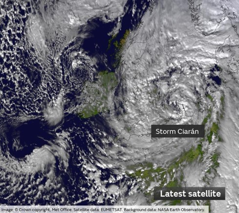
Ciarán began as a shallow low that developed over the Ohio Valley, USA, on Sunday 29th October, associated with very strong temperature gradients in the region. The low emerged off the coast of New England soon after, positioned favorably within a notably strong (200 mph) jet stream. It was named Ciarán by the UK Met Office, and Emir by the Free University of Berlin. On Wednesday 1st November, the storm explosively deepened by 34 mb in 24 hours over warm sea surface temperatures, making Ciarán a bomb cyclone. The low-pressure center of Ciarán arrived in south-western parts of England overnight into Thursday 2nd November at 952 mb, the lowest pressure ever recorded in England and Wales in November. As is typical, the strongest winds occurred to the south of the low-pressure center, with wind gusts up to 129 recorded in the Brittany region of north-western France, and 93 mph (150 km/h) at Jersey Airport. High gusts were also seen along coastal southern England, as well as parts of Belgium and Netherlands. However, high exposure regions here were spared the worst impacts from the storm. Rainfall totals in north-western Europe were less remarkable, but following a period of sustained wet weather, there was some further flooding in parts of southern England. Growing in size, the storm then began to meander northwards and weaken. However, the long trailing cold front from Ciarán spawned another shallow low over the Alps overnight Thursday into Friday, causing significant flooding in southern parts of Europe, most notably the Tuscany region of Italy, far away from the center of the storm. This flooding, along with the impacts in France and elsewhere from windstorm Domingos over the past weekend, may contribute losses to this event, which depending on hours clauses could be considered a single loss occurrence along with Ciarán’s wind impacts as described above. Users should note carefully, however, that the modeling and loss estimates with this ALERT do not include the flooding in Italy nor this past weekend’s impacts from Domingos.

Reported Damage
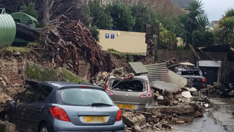
Ciarán’s impacts were most pronounced in northwest France and the Channel Islands. In France, the worst damage was in the northwest; in Brest, images on news and social media showed widespread tree damage, including many trees uprooted, blocking roads and damaging homes and other buildings. Reports out of this area also noted a crane which had been toppled by the winds, causing damage and leading to some evacuations of nearby buildings. Similar impacts were observed in the Channel Islands – Jersey in particular was very hard hit, with some of the more extreme roof and structural damage there likely caused by a strong tornado that was spawned by the storm. Jersey also saw golf ball sized hail which contributed to both roof as well as automobile damage. The large amount of tree related damage from this storm was exacerbated by the fact that most trees in the region still have leaves on them, and the ground was quite saturated, making it more likely for trees to become uprooted or fall over in general.

Damage near Highlands College in Jersey following Ciarán (BBC/Mark Laurence)
Other Resources
Though the flooding in Italy was not modeled or included in the loss estimates provided with this ALERT, Verisk’s fully probabilistic Inland Flood Model for Italy provides a comprehensive view of the potential inland flood risk in this highly prone country. The model provides 10,000 simulated years of potential flood event scenarios, physically modeled at a 25-meter resolution, informed by ISPRA, Hanze, and other industry data, and including probabilistic modeling of flood defenses across the country.
The Copernicus Emergency Management Service has also been activated for this event, and shapefiles of flooding extents are available from them for download.
No additional ALERTs are planned for this event at this time. If you have any additional questions, please contact your Verisk representative.
Custom Events | Downloads
Posting Date: November 8, 2023, 5:00:00 AM
The information provided herein is strictly confidential and is solely for the use of Verisk clients; disclosure to others is prohibited.
Simulated Event Sets
These event sets contain five custom modeled scenarios for Ciarán, allowing for uncertainty in modeled wind speeds.
| Product | Description | Download |
|---|---|---|
| Touchstone | Selected set of simulated scenarios | |
| Touchstone Re | Selected set of simulated scenarios |
Loss Based Similar Stochastic Event IDs
These stochastic events were selected as best matches to the insured industry loss footprints generated by the custom modeled scenarios in the Simulated Event Set
Additional Downloads
Note: Additional downloads related to the posting are listed below. Please use the appropriate application to view these files.
| Title | File Type | Description | Download |
|---|---|---|---|
| Modeled Wind Footprint Shapefile | .zip | A shapefile for the median loss scenario wind footprint from the Simulated Event Set, in meters per second |