Hurricane Isaac
Status: Closed
| Type of posting | Posting date(EST): | Summary | Downloads |
|---|---|---|---|
| Post Landfall 1 | 8/30/2012 7:30:00 PM |
|
|
| Landfall | 8/29/2012 9:50:00 AM |
|
|
| Pre-Landfall 7 | 8/28/2012 9:00:00 AM |
|
|
| Pre-Landfall 6 | 8/27/2012 1:00:00 PM |
|
|
| Pre-Landfall 5 | 8/26/2012 6:20:00 AM |
|
|
| Pre-Landfall 4 | 8/25/2012 6:45:00 AM |
|
|
| Pre-Landfall 3 | 8/24/2012 10:20:00 AM |
|
|
| Pre-Landfall 2 | 8/23/2012 11:00:00 AM |
|
|
| Pre-Landfall 1 | 8/22/2012 11:20:00 AM |
|
Pre-Landfall 6 | Summary
Posting Date: August 27, 2012, 1:00:00 PM
As of today’s 8:00 a.m. EDT advisory from the National Hurricane Center (NHC), Tropical Storm Isaac has passed through the Florida Keys—where it delivered wind and rain yesterday, but caused little damage—and moved into the Gulf of Mexico; the storm is currently about 360 miles southeast of the mouth of the Mississippi River, moving west-northwest at 14 mph. Isaac’s forward speed has decreased since yesterday, while its maximum sustained winds—at 65 mph—have remained constant. The NHC expects Isaac to reach hurricane status sometime this evening. Favorable wind shear conditions and warm sea surface temperature conditions, as reported by AIR’s ClimateCast Atlantic Hurricane Conditions®, will facilitate this process.
Tropical storm force winds (>39 mph) currently extend outward from the center 240 miles. Thus Isaac remains a very large storm. At this point, most of the western Florida peninsula will have escaped the worst of the threat from Isaac, though rainfall accumulations of one to three inches are possible over central and southern Florida, with local maximum amounts of up to 15 inches. Isolated tornadoes are still possible in central Florida.
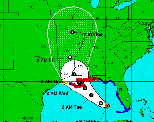
After yet another westward shift in the NHC forecast track, the landfall target now seems to be settling around the north central Gulf, near New Orleans. Landfall is forecast for Wednesday morning, August 29, the same day that Hurricane Katrina arrived on the Louisiana coast in 2005. Isaac will likely be a Category 2 hurricane at the time of landfall; Katrina was a strong Category 3 hurricane at landfall.
Reported Impacts
Yesterday, Isaac moved past the Florida Keys, causing little harm. Monroe County Sheriff's spokeswoman said there were few reports of damage as the storm crossed near Key West. Farther north, heavy rainfall was reported in Tampa—the site of this week’s Republican National Convention. Flooding in Tampa prompted the closure of three main roads and delayed the convention’s planned start one day until tomorrow. Even though the storm moved well west of Tampa, tropical storm-force winds and heavy rains impacted the area because of Isaac's large size. Today, as the remnants of Isaac move across South Florida, much of it remains under a tornado watch.
Farther north, along the Gulf Coast, a state of emergency has been declared in four states (Louisiana, Mississippi, Alabama and Florida), and the approaching storm has prompted evacuations along a wide stretch of coastline; 53,000 residents of St. Charles Parish near New Orleans were told to leave. Residents have begun boarding up homes and stocking up on food and water this weekend and today; grocery stores and fuel stations reported significant business. In advance of the storm, Amtrak has cancelled train service in Louisiana for Tuesday and Wednesday.
Before reaching Florida, Isaac caused eight deaths in Haiti and two more in the Dominican Republic. It also downed trees and power lines in Cuba.
Offshore Assets
In the Gulf of Mexico, oil companies began shutting down offshore oil and gas rigs this weekend. BP Plc, the biggest Gulf producer, evacuated all its installations and temporarily halted production in the Gulf Sunday; earlier, it had pulled workers from its Thunder Horse platform, the world’s largest. Royal Dutch Shell, meanwhile, withdrew all workers and suspended production in the eastern Gulf. In the central Gulf, it withdrew all but essential personnel (and cut production). Other oil companies with offshore rigs in the Gulf have followed suit.
According to a news release issued yesterday by the federal Bureau of Safety and Environmental Enforcement (BSEE), personnel have been evacuated from 39 production platforms, equivalent to 6.54 percent of the manned platforms in the Gulf of Mexico. Approximately 24 percent of the daily oil production and approximately 8.25 percent of the current daily natural gas production in the Gulf of Mexico has been shut-in.
Forecast Track and Intensity
Isaac’s sustained winds have remained constant for the past 24 hours, at 65 mph. Data from Hurricane Hunter aircraft indicate that Isaac has not strengthened since yesterday, possibly because the storm is battling with dry low- to mid-level dry air in the western side of its circulation. Conditions should be favorable for intensification today, however, and Isaac is now expected to achieve hurricane intensity in the next 24 hours.
According to the NHC, Isaac’s movement—west-northwest near 14 mph—is expected to continue today, with a gradual decrease in forward speed. By tomorrow, a turn toward the northwest is expected. On the forecast track, Isaac’s center will move over the eastern Gulf of Mexico today and approach the northern Gulf coast in the hurricane warning area tomorrow. A hurricane warning is in effect east of Morgan City, Louisiana, to Destin, Florida, including Metropolitan New Orleans. Tropical storm conditions are expected to reach the northern Gulf coast in the hurricane warning area later today, with hurricane conditions expected in this area on Tuesday.
With respect to Isaac’s potential track and landfall location, the dynamical forecast models are now in greater agreement than they had been prior to and over the weekend. Over the past 24 hours the numerical model guidance has converged a little more tightly around the New Orleans/Mississippi delta area—about 100 miles farther west than was expected on Friday. This shift—which had been difficult to anticipate due to a weakly established steering current in the Gulf—makes a substantial difference to the coastal populations who are now on high alert. (Despite the shifts in track, the ClimateCast U.S. Hurricane Risk Index has remained relatively stable over the past several days. This is partly due to the relatively lower exposure concentration at risk compared to the southern Florida metro areas of Miami and Tampa, where losses add up quickly even for marginal storms.)
The track is not the only fluctuating element of the forecast. The intensity forecast has also been hard to establish. Despite the lack of significant limiting environmental factors (e.g., wind shear or cooler sea surface temperatures), Isaac has not developed a well-defined structure at any point its lifetime to date. Though it has been forecast to reach hurricane status several times throughout the past several days, it has not done so yet. The current forecast—which has Isaac finally reaching hurricane status tonight—delays that development yet again. Even so, Isaac reaching hurricane status tonight leaves 24 hours of time for additional development prior to landfall; within that window, Isaac could reach Category 2 intensity. How much stronger Isaac will become will depend in part on the storm's track—that is, how much time it will spend over the warm waters of the Gulf of Mexico.
Further adding to the uncertainty around Isaac’s forecast intensity is the fact that the storm will be moving over some of the warmest waters it has encountered to date, so a period of rapid intensification that leads to even stronger winds cannot be ruled out.
Though the expected track has the storm dissipating quickly once ashore, a small set of the dynamical forecast models, which show Isaac tracking along the western edge of the cone, bring strong winds well inland. These scenarios—which put inland exposure at risk—take the storm over a locally warm region of the Gulf for a longer period of time.