Hurricane Beryl
Status: Closed
SSEs Mexico | Summary
Posting Date: July 5, 2024, 12:00:00 PM
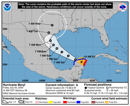
Hurricane Beryl made landfall Friday morning on the Yucatan peninsula of Mexico, just northeast of Tulum. As of 10:00am CDT, Beryl was located about 680 miles east-southweast of Brownsville, Texas, with estimated 1-minute sustained winds of 85 mph and a minimum central pressure of 980 mb. Beryl is moving at west-northwest at 16 mph.
ALERT™ subscribers can download similar stochastic event (SSE) IDs for Hurricane Beryl’s impacts in Jamaica from the Downloads tab of this posting on the ALERT website. Compatible with Touchstone® and Touchstone Re™, the SSEs were selected based on the event’s track, minimum central pressure, estimated winds, forward speed, and landfall angle. They were selected primarily for impacts in Mexico.
 National Hurricane Center Forecast for Beryl as of 10:00am CDT, July 5th
Beryl is forecast to cross the Gulf of Mexico after departing the Yucatan and should restrengthen somewhat as it makes a turn to the northwest. Wind shear may abate as the storm approaches the western Gulf Coast, most likely southern Texas, which complicates the intensity forecast.
Assuming the official National Hurricane Center forecast continues to show a hurricane strength landfall in the U.S. on Monday, the Verisk ALERT team will issue similar stochastic events each day from Saturday through Monday, posting at around 10:00am EDT each day. In the meantime, please contact your Verisk representative with any additional questions.
SSEs Mexico | Downloads
Posting Date: July 5, 2024, 12:00:00 PM
The information provided herein is strictly confidential and is solely for the use of Verisk clients; disclosure to others is prohibited.
Similar Stochastic Event IDs
Note: These lists give event IDs taken from our stochastic catalog that have similar meterological characteristics as Hurricane Beryl's impact on Mexico.